
The Harman family is widely known in Tazewell County, Virginia, but did you know that old Mathias has a Pike County connection? Mathias Harman built the first settlement in Pike County in 1789. He informs us of that settlement in a legal deposition of his own words. The most current information comes in the form of a court document in the year 1818. Within this deposition, Mathias Harman, Daniel Harman, Henry Skaggs, and Charles Skaggs, are of the first Adventurers to the Sandy Valley. Mathias was born in 1736, give or take. He was the son of Heinrich Adam Harman and Louisa Katrina Hermann and the husband of Lydia (Skaggs) Harman. He died April 2, 1832,
Mathias and Lydia gave birth to Louisa (married Thomas Bailey Christian), Mathias Harman Jr., (married Nancy Vance), Katherine (married Robert Beavers), Rebecca Harman, Adam Harman (married Ruth Christian), and Pheobe (married Moses Beavers). Charles (married Lucy Thompson) and Henry Skaggs (married Mary Thompson) were brothers of Lydia. Her parents are still unknown or unproven.
Rumors of Mathias’ skills as a hunter and Indian fighter have become legendary, traits he shared with the Skaggs family. His physique has been described as small in stature, but fast on his feet.[1]
[1] Deposition of Wm. Ratliff – 27 April, 1836 at the home of Wm. Skaggs, Aleck Fork of Pitman Creek: “I was acquainted with Moses Skaggs of Green County, KY. He had 4 sisters, to wit: Susannah, wife of Richard Whitt; Lydia, wife of Mathias Harman; Elizabeth “Betsy,” wife of John Hankins; and Nancy, wife of Wm. Meridy. I was quite intimate with them in Virginia. I knew them before they married. Moses had a brother named John Skaggs. I knew the brothers of Moses Skaggs. They were Henry, Jam., Charles, John, Richard, and Jacob Skaggs. I knew them in Kentucky and they all raised large families.” Deposition of Frances Samples – 27 April 1836: “I was familiar with Moses Skaggs who died in Green County about 40 years ago. He had 4 sisters, to wit: Susannah, wife of Richard Whitt; Lydia, wife of Mathias Harman; Elizabeth, wife of John Hankins; and Nancy, wife of William Meridy. They lived in Virginia. When I knew them, Moses had 6 brothers: Henry, John, James, Charles, Richard, and Jacob Skaggs. I knew them in Kentucky and they all raised large families.” Deposition of Frances Samples – 27 April 1836: “I was familiar with Moses Skaggs who died in Green County about 40 years ago. He had 4 sisters, to wit: Susannah, wife of Richard Whitt; Lydia, wife of Mathias Harman; Elizabeth, wife of John Hankins; and Nancy, wife of William Meridy. They lived in Virginia. When I knew them, Moses had 6 brothers: Henry, John, James, Charles, Richard and Jacob.
By all accounts, tradition also tells us the Harman family had some kind of building up near Johns Creek, near present-day Paintsville. Some writers have called it a fort while others referred to a blockhouse. Some used both. No document supports the contention that the Harmans owned land near Paintsville at that early date. We do know of one settlement which can be proven, and old Mathias called it his first settlement.
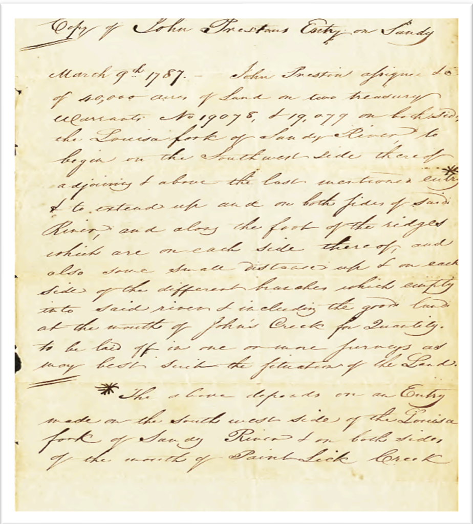
In the year 1787, Mathias Harman, Daniel Harman, Charles Skaggs, and Henry Skaggs had come into the valley of Louisa Fork as Adventurers (a common term for the time). They were operating in the name of, and under contract with, John Preston and John Smith. Those parties were all part of the Loyal Land Company, directed to survey land under grants numbers 19078 and 19079, on March 9, 1787. After that date, and situated in Pike County (then Floyd), they formed a settlement located on Harmans Bottom. This is a copy from Pike County of the original Preston survey from Pike County Clerk John Mims in 1834.

3
The establishment of a Station was for protection against both the elements and Indians, who had kept the fuse burning over the “Kentucke” hunting lands where the Indians believed men such as Harman had imposed themselves. History tells us of the 1770 treaty of Lochaber, and soon thereafter was the treaty with Virginia in 1772, wherein the Cherokee ceded land to the Virginia Colony. Part of this ceded land was the Big Sandy Valley, a valued land of the Scioto Cherokee and Shawnee. Not long afterward, a new Virginia law applied to the soon-to-be “Kentucke” lands. It was known as the “Corn Patch” and “Cabin Rights” law. This act was intended to develop the lands in the name of Virginia, and applied to settlers who took advantage prior to January 1, 1778. This law did apply to eastern Kentucky, but seems not to have been used in regards to eastern Kentucky, mainly because the land was rugged inhospitable to settlement. John Smith and John Preston, speculators of the Loyal Land Company, set forth to occupy the valley.
Land speculation in the valley began with the Harmans and Skaggs, prior to Kentucky statehood, as proven by contract in February of 1787. Preston and Smith had done prior work for the Loyal Land Company in Montgomery, Wythe, and other Virginia counties. They were “contracting” with Mathias Harman, Daniel Harman, Charles Skaggs, and Henry Skaggs for speculation in the soon-to-be state of Kentucky. But the Indian trails ran in this very area and made it extremely dangerous to work or live in the Sandy Valley. Here is where the Indians held captive Jenny Wiley. They used the trails reaching up into the Scioto Valley of Ohio and down along the Big Sandy River well into the valleys of Virginia. For quite some time, especially after the battle of Point Pleasant on October 10, 1774, the Shawnee and the Cherokee ran in small bands, murdering, burning, looting, and taking captives as noted in Virginia state documents. Newspapers recorded many such occurrences upon the settlements in Virginia and Tennessee. Henry P. Scalf, a well-known Floyd County historian during the 1950s, wrote in his Susquicentennial of Floyd County: “The Harmans built a hunting cabin at the mouth of Johns Creek as early as 1755, and a few years earlier in 1749. George Draper, Adam and Jacob Harman, along with Casper Mansker and Michael Stoner, went on hunting expeditions along Clinch and Big Sandy. On one hunting expedition George Draper and a McGary are killed by Indians.”[2] Scalf continued, telling us that in 1789, Mathias Harman founded Harmans Station at the mouth of Johns Creek, just above Paintsville, and that a fort had been abandoned and burned by Indians in 1790.
[2]Book – Calendar of the Kentucky Papers of the Draper Manuscripts; 1837 Aug. 9 27CC38-40 A Mountaineer. “Giles Court House, Va. Article entitled: Indian Reminiscences; or, The Narrative of Geo. Harman.” Son of Henry Harman of Walker’s Creek, Va., in 1783; service under Captain Hays and Col. John Preston on Bluestone and Clinch rivers 1786-88; he and his father, a younger brother, and George Draper engaged in a desperate fight with the Wolf and seven other Indians. Newspaper clipping from the Wytheville (Va.) Republican. 3 pp.
From court testimony, Mathias Harman stated under oath that he lived between Cowpen Creek and Mud Creek in Floyd County in 1789, in what is now Pike County. Connelley tells us when Jenny Wiley, wife of Thomas Wiley, was taken captive by a band of Indians near Walkers Mountain in Virginia, Mathias Harman and others were sent out into the wilderness looking for her. We know for sure this was not this Mathias Harman Sr. We know from records that Jenny Wiley was taken in October 1789, when Mathias Harmon and the Skaggs brothers were living and erecting a settlement on the Station Bottom. We also know from the “Feb. 1787 contract” that Mathias Harman was surveying land from March 1787 until 1789, when he established his own station.
Therefore, the above information begs the question: did a building exist at the mouth of Johns Creek near modern Paintsville? What we can be sure of is that locators like Skaggs and Harman needed lodging for surveying, so it is quite possible that some kind of building or temporary lean-to was near that area. John Hanks, a worker on the Vancouver Station, called it a cabin (not a blockhouse or fort) and having been built on the Sandy in early spring 1789. John Hanks had advised that he was witness to Mrs. Wiley being rescued and noted a cabin. John Hanks’ affidavit was one of two supposed firsthand witnesses of her escape:[3] [4]
“I was employed by Charles Vancouver in the month of February, 1789, along with several other men, to go to the forks of the Big Sandy River, for the purpose of settling, clearing and improving the Vancouver tract, situated on the point formed by the junction of the Tug and Levisa Forks, and near where the town of Louisa now stands. In March, 1789, shortly after Vancouver and his men settled on said point, the Indians stole all their horses but one, which they killed. We all, about ten in number, except three or four of Vancouver’s men, remained there during the year, and left the next March, except three or four to hold possession.
Preston on Bluestone and Clinch rivers 1786-88; he and his father, a younger brother, and George Draper engaged in a desperate fight with the Wolf and seven other Indians. Newspaper clipping from the Wytheville (Va.) Republican. 3 pp.[3]Book; History of Kentucky (1922), Vol 1, pages 22-23.
[4]Draper Manuscript 12 CC 138-144 not dated, Wisconsin Historical Society, an Interview with Rev. John Dabney Shane with John Hanks, one of the Pioneers of Vancouvers Station. Per Hanks affidavit, a man named Harmar (or Harman by tradition) built a house in the spring of 1789 near the Sandy.
But they were driven off in April, 1790, by the Indians. Vancouver went east in May 1789, for a stock of goods, and returned in the fall of the same year. We had to go to the mouth of the Kanawha River, a distance of eighty-seven miles for corn, and no one was settled near us. Probably the nearest was a fort about thirty or forty miles away, and was built maybe early in 1790. The fort we built consisted of three cabins and some pens made of logs, like corn cribs, and reached from one cabin to the other.
“We raised some vegetables and deadened several acres of ground, say about eighteen, on the point, but the horses being stolen, we were unable to raise a crop. (Signed by John Hanks)
“During this period, the story of Jenny Wiley was acted out. Jenny Wiley was a woman that had been kept a prisoner by the Indians nearly three years [here Johns Hanks is wrong]. There were only six of them, and they had never taken her across the Ohio. She was pregnant when the Indians got her and when her time came, the Indians left her in a cave and went and stayed away five days. When they returned, they removed the child and she never heard of it more. She had been taken off Clinch and kept during all this time on [illegible], now Jenny’s Creek, I suppose, for Jenny’s Creek took its name from her.”
“One day we were going up Big Sandy on a hunting spree by the water, some twenty or thirty miles. The Indians were out in a very thick bushy place. On hearing our guns, they returned to their encampment and endeavored to make the alarm known to the other Indians and yet conceal it from this woman. She judged, however, from their motion that there were white men in the neighborhood along the river. When they left and went away, she determined to leave, too. Following Jenny’s Creek to Big Paint, and that down to the Sandy, she came opposite where one Harmer [Harmen] had built a cabin that spring after we had come. Harmer was a great old hunter. He had at this time taken his canoe and gone down to Vancouvers to drink whiskey. When Jenny Wiley called, a young man came and set her over on a raft and then went down to Vancouvers by land after Harmer. Angus Ross, one of our men, went back in the canoe with them. Vancouver sent her up dresses as she hadn’t when she came a speck of woman stuff on her.
“She was at Phillip Hammond’s at Jeffersonville and at my place here some twenty-five or thirty years ago. She inquired for me, but I was not home at the time, and don’t now recollect what I heard of her.”
Fred T. May recently wrote a book on land grant surveys made in Kentucky along the Big Sandy River, an exceptionally thorough and well-done work of craftmanship whose detail is beyond expectations for any genealogist. On pages 218-219 are two plats (May pointed out to me) at the mouth of Johns Creek[5] – mentioning Enoch Smith in 1784, (OK 2700.0, Treasury Warrant No. 19152). The land is shown at the mouth of “upper” Johns Creek, on November 1797, for William Shepherd assignee of William Jenkins. This is some of the same lands surveyed by Harmans-Skaggs about March 9, 1787, under grants 19078 and 19079, and “entered” later by John Graham for Smith and Preston. May also advised of several other lands being surveyed many times over.
Virginia land grants show Enoch Smith received three grants located near Hinkston Creek, at Mount Sterling, Kentucky, where he and Calk resided after the Boonesborough trip in 1775. The William Calk diary puts Enoch Smith near the Rapidan River in Virginia in March 1775, where Calk joins up with Abraham Hanks, Phillip Drake, and Robert Whitledge for an excursion to Boones Fort.[6] Enoch Smith has a son, William, born in 1772 in Shenandoah County, Virginia.
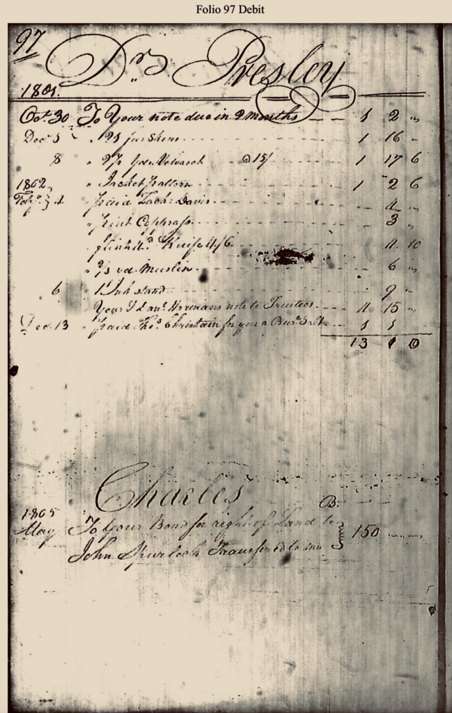
There are no known land grant entries from the locators Harman and Skaggs, but this is not unusual. It is known from court testimony that the land was surveyed and entered between 1800 and 1820 by a young surveyor named John Graham. His survey was made over several years as an assignee of John Preston. The reasons are unclear as to what happened with Preston and Smith regarding their earlier surveys done by Harman and Skaggs. What one can be sure of is that land entries 19078 and 19079 are surveys done by these four Adventurers.In his book, Fred T. May mentions the store ledger of John Graham, showing the accounts of Charles Skaggs in 1805. On page 97, the entries show that Charles Skaggs received $150 for land he sold to John Spurlock, which was then transferred to John Graham from John Spurlock. It is also shown from Graham’s testimony that he purchased the Skaggs property by acquiring it from Spurlock, who had purchased it from Skaggs.
[5]This land is very close to that of the John Creek land which Harman Station is shown on today.
[6]Book – Register of the Kentucky Papers Vol. 20, page 239 – In 1773 Enoch Smith, Richard Spur, John Wilkerson, and William _, pioneering on the headwaters of the Johns Creek, in what is now Pike County, built a horse pen of logs which stood for many years. It was located about five miles from Pikeville, and has been used as a starting point in many of the old land surveys of that vicinity. Whether they built a cabin adjoining and occupied this land about this time is not revealed, but it seems doubtful because of the hostility of the Indians in this region at the time.

Much has been written on old Mathias Harmon, but the best account regarding his early lands and his introduction into the Kentucky wilderness as part of the “locators and adventurers” is from his son, Mathias Harman, Jr. in a court transcript wherein he testified Harmans Bottom:
The deponent Mathias Harman Jr. being of lawful age and first duly sworn deposeth and saith:
Q. 1st by Plaintiff – Was not Mathias Harman Sr., equal partner in the location with John Preston, Scaggs and others made on Sandy River State of Kentucky?
Ans. – He was equal partner with the “locators” in all Preston locations on Sandy River and its branches.
Q. 2nd by same – What part was Mathias Harman entitled to, as one of the “Locators”?
Ans. – To one third of all the locations. [later it would read as one fourth of one third]
Q. 3rd by same – Was not Mathias Harman Sr one of the 1st settlers on Sandy agreeable to the proclamation of John Preston to the first adventurers and where did he settle as adventurers.
Ans. – He was one of the first Adventurers.
Q. 4th by same – Was not Mathias Harman the first settler in or on the bottom on the country side and down the river from the bottom called and known by the Station Bottom and did he not sell the same to William McGuire, and did not the court decree a title to John Hackworth, as assignee of said McGuire.
Ans. – He was the 1st settler on the Bottom above named.
This testimony by the younger Harman, and the two Virginia-Kentucky lawsuits, were largely unrecognized by historians because they did not know about the case in Tazewell, Virginia. Scalf wrote in his book, “Kentucky’s Last Frontier,” about the station land per Connelly and, in part, about the court case coming out of Floyd County Kentucky court books. Scalf did not have the case of Mathias Harman versus William McGuire from Tazewell County, making his interpretation of the case of John Hackworth versus John Graham skewed. Besides the two original cases, also found in Tazewell court books are other entries of a court case between Mathias Harman and John Graham, some as early as 1803, which probably involved the so-called Station Bottom land also.
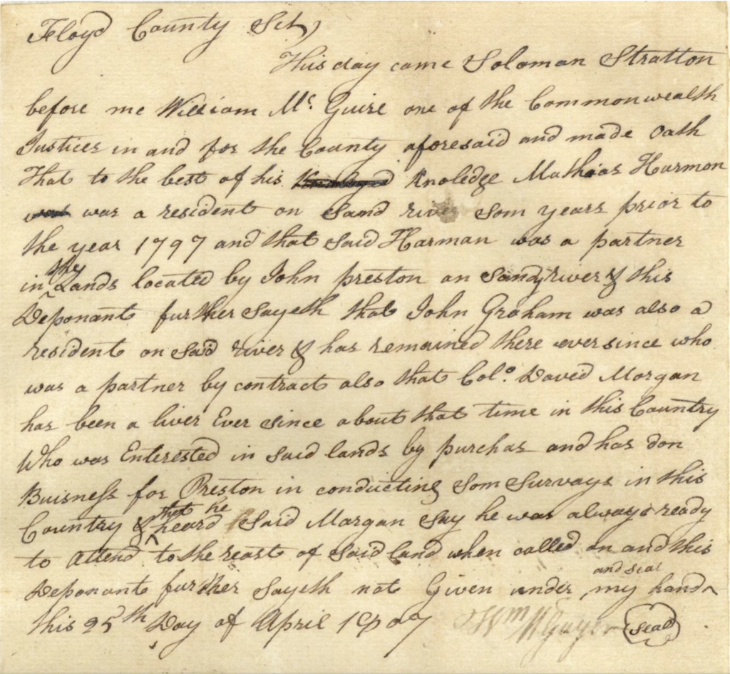
One such entry was “May 13, 1803 – Mathias Harman vs. John Graham. Motion of the plaintiff, by his council, and it appearing to the court that the defendant had legal notice of this motion, it is ordered that a commission issue for the examination of Lovice Christian, Solomon Stratton and Thomas Stratton to be read as evidence in this cause. The said commission is to be directed to Cornelius McGuire, Goodwin Likins, James Brown, Abraham Beavers, and John Spurlock to be executed by them or any three of them.”
By 16 March 1805, a jury found for the plaintiff in Matthias Harman versus John Graham: “Verdict: find for plaintiff L12.15.6 damages against defendant. And costs.” This is the sum total of what is known about this 1803 case that lasted until 1805 in Tazewell County.
As was true in every court case or court action, there was a Bill filed by the orator (or plaintiff) against the defendant. In all legal actions, after the Bill was filed, the defendant filed his Answer. Subpoenas were issued and evidentiary depositions were taken. A court date was then set, and deposition evidence filed. The judge or jury could then make a decision of its outcome.
Just as in the Floyd County case of John Hackworth versus John Graham, later in Pike County came the second case of Mathias Harman versus William McGuire in Wythe and Tazewell counties. These two overlapping cases have records dating back to the John Preston and John Smith land grants of March 1787, and the “contract” made between the Harmans-Skaggs and Preston-Smith in February 1787, and presented as evidence. This was a contract to employ four men to become “Adventurers” or “Locators” to survey land on the Big Sandy and entered as evidence marked (A). From the court case comes this contract written as it is shown:
“1787 Contract – Here follows the agreement between Preston, Smith, Skaggs &c., which is marked (A) & is in the following words and figures to wit; Articles of agreements made and concluded on by and between John Preston & John Smith of the county of Montgomery County & Daniel Harman, Charles Skaggs and the said Daniel and Charles on behalf of Mathias Harman and Henry Skaggs of the other part witnessed that the said Preston and Smith doth agree and bind themselves to procure land office Treasury Warrants to be amount of one hundred thousand acres more or less for all which warrants the said Daniel and Charles for themselves and on behalf of the said Henry and Mathias doth agree and bind themselves to find and deliver new lands of good quantity to the covenant alone mentioned yet vacant and unlocated to the said Preston and Smith to enter and locate the said warrant on and also conduct and the survey or around said lands and all other vacant lands which they may discover or at this time know of and for which the said Preston and Smith are to pay the expenses for surveying the same and after the same is surveyed or patented to assign as make over one third part thereof according to quantity, the said Daniel, Charles, Henry nor Mathias are not one or either of them to give information to any person or persons except to the said Preston and Smith concerning said land should the land which said Daniel, Charles, Henry and Mathias have discovered land which lies on the waters of Sandy River be entered before the date then the above obligation to be void else to remain in full force. To the true performance of each and every of the above articles due the said John Preston and John Smith & Daniel Harman, Charles Skaggs, per themselves and on behalf of Henry Skaggs and Mathias Harman & bind ourselves and each of our heirs’ executors & c., admins, the one to the other in the penal sum of ten thousand pounds current money of Virginia to _ by the party _ to the party observing in witness whereof we have entered changeably set our hands and seal this 7th February 1787. Signed by; John Preston, John Smith, Charles Skaggs, Henry Skaggs, Self for Daniel Harman for ref & Mathias Harman. Attest James Heirs, William Preston.”
By 1803, Mathias Harman was living back in Tazewell and had sold his Station Bottom property to William McGuire. (Curiously enough, in the year 1803, Mathias was suing John Graham in Tazewell). A bond, or “Bill of Sale,” was entered into from Mathias Harman to William McGuire of Tazewell, Virginia for the land. This was the first land settled on, per Mathias Harman, under sworn testimony and by deed. The land was sold by bond to McGuire because Harman had no legal deed for the land from Preston and Smith for the land; they had only the contract. The above 1787 agreement between the parties stated that Harmans and Skaggs would receive the land of their choice from the lands surveyed by them. The land was again sold in 1816, by bond, by William McGuire to John Hackworth:
“1803 Harman Bond to McGuire – Know all persons, whosoever it may concur in that I, Maythyes Harman of the county of Tazewell and State of Virginia and in consideration of a sum of one hundred pounds to me in hand paid by Wm. McGuire of said court and state aforesaid the receipt of which is hereby acknowledge have bargained and sold given free and peaceable permission sold by these presents according to the true interest & meaning of the same make over unto the said William McGuire is heir and assigns all that tract of land which lays on Sandy river known by the first settling and living on as it on the contrary side of the river from the Station Bottom down the river in Floyd County beginning in the narrows at the upper end of Grahams Botton in the narrows running up the river for quantity. Concluding the improvements and all lands fit for cultivation for 400 hundred acers more or less, if Mr. John Preston holds the land by his claim, then, I myself my heirs executors admin., then bargain promises unto the said William McGuire his heirs executors & admin., and assigns for the sum of two dollars per acre paid in cattle and horses at their real value in cash to make declare right and title to the said land warrant and forever defend as witness my hand and seal this thirteenth day of June one thousand eight hundred and three. Mathyes Harman (Seal) Teste Henry Harrison and Wm Wingo.”
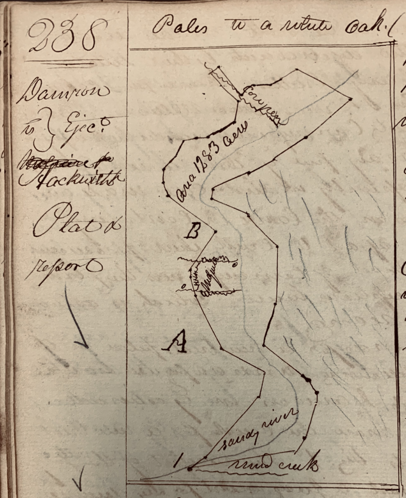
The Station Bottom continued to be a spot of contention. Next involved was a third court suit of Richard Damron versus John Hackworth. Located in Floyd County, the first case starts on page 238, Floyd Court Book, which locates the below plat used in Damron versus Hackworth for a petition for ejectment off the land because John Graham (assignee of Preston and Smith) had sold the 1,283 acres of Station Bottom to Richard Damron. The contest arose from a problem wherein John Hackworth had purchased the land from William McGuire in 1816, and held the bond, but, like Harman, had no deed from Preston. So Damron sued for an ejectment of John Hackworth, knowing full well that Hackworth had been living on the land some 10 years at this point had renamed the Station Bottom to Hackworth Bottom. This was the John Graham surveyor entry in the ejectment suit against Hackworth.
In total there are 102 pages of exhibits, deeds, testimony, bills, and answers shown in the Wythe and Tazewell portion of the transcripts. In the earlier Floyd County case of Hackworth versus Graham are many more pages of court entries over this 1,283-acre survey which the said “locators” had chosen for themselves as their one-third of one-fourth interest, where Harman Bottom was located. The entirety of these cases related to Mathias Harman Sr., and son Mathias Harman Jr. (Mathias and Nancy Vance Harman), Daniel Harman, Adam Harman, William Harman, and others are all mentioned in these court records. This is the “Bill” filed by Mathias Harman Jr., who sued in Wythe and moved to Tazewell, per his father who had given him power of attorney:
“Bill filed in Tazewell County by Mathias Harman Jr (per his father) – To the Honorable Allen Taylor, Judge of the Superior Court of Chancery, holder of Wythe Court House – Humbly complaining and showeth to your Honor, your orator Mathias Harman, and that on the 13th day of June 1803, Mathias Harman (Sr), the father of your orator (Jr), sold to William McGuire a tract of land containing 400 acres more or less lying on Sandy within Floyd County, Kentucky, for which the said McGuire was to pay the said Mathias Harman two dollars per acre in cattle and horses at their real value in cash, if the said land could be held under John Preston claim and the said Mathias Harman was to make a title for the McGuire, as will more fully appear from copy of a title bond (A) executed and the said Mathias Harman delivered immediate procession of the said land to the said William McGuire who obtained possession. Thereof, until about the year 1816, when he sold the same to one John Hackworth to whom the title bond aforesaid was assigned by said McGuire and the said Hackworth here since retained possession of the said land. One John Graham improperly obtained a grant for the said land which was included in a survey of 1,283 acres made in the name of John Smith and John Preston, the survey was made in Virginia but the grant issued by the State of Kentucky in pursuance of the compact between the two states. Graham conveyed the legal title for the whole of the land to Richard Damron, and Damron instituted an action of ejectment for the said land in the circuit court of Floyd County Kentucky, against the said Hackworth, McGuire, and others, who were in possession of the said land and judgments at law were rendered in favor of the plaintiff in said ejectments, the said Hackworth who claimed under the title bond aforesaid assigned to Hackworth as aforesaid, filed his bill of equity in the circuit court of Floyd County against the said Graham, Damron, and others, praying that the judgment reentered in the action of ejectment might be perpetually enjoyed, and that the legal title might be decreed to him, and me, pursuance of a decree of therewith exhibited marked (B). The said land was decreed to said Hackworth.
“The said Mathias Harman has offered to have the land surveyed to a section the quantity thereof in order that he might receive his pay therefore, and give any pursuance required for the goodness of the title but the said McGuire refused to have the same done as will appear from the papers herewith exhibited marked (C) (D) – Your orator further alleges that the said McGuire hath never paid the said Mathias Harman any part of the purchase money for the said land. That the said McGuire and Hackworth to whom he sold, have been in the actual occupancy and enjoyment of the said, and since the date of the title bond (A) until the present time, that their title thereto has been rendered in disputable by the decision of the court of the appeals of Kentucky. Your orator alleges that the said Mathias Harman hath transferred to your orator for a valuable consideration his claim for the purchase endorsement on the copy of the said title bond. The prayer of your orator therefore is that the William McGuire and the said Mathias Harman be made parties defendants to this bill, that they be required to answer it several allegations on oath as fully as if the same were again repealed and specially interrogated; that the said McGuire be deemed to pay to your orator $800.00 the purchase money for said land with interest thereon from the 13th day of June 1803 until paid, etc., etc.”
Answers in depositions state that old Mathias Harman lived on the land 12 to 14 years. While living there he made improvements. On June 13, 1803 he sold his improvements to William McGuire for 100 pounds, giving only “bond” until Mathias could obtain a clear title from John Preston. Then, McGuire would owe Harman the equivalent in horse flesh at $2 an acre, for 400 acres located between Cowpen and Mud Creeks, which he never paid.
Later, in 1816, William McGuire sold to John Hackworth this same improvement 1816 for $250. When John Hackworth died, his widow, Polly, sold to James Honaker in 1836. There are several more cases in the Kentucky Archives regarding the land of Hackworth Heirs versus Honaker Heirs.
As stated previously, the third case sprang from Richard Damron because he had purchased Harman’s bottom land from John Graham in 1814, but Graham sold him the entire 1,283 acres of the Harman and Skaggs legacy for surveying the lands in the Sandy Valley:
Graham to Damron – Here follows the deed Graham to Damron referred to, made part of the Bill, to wit; This indenture made this 12th day of Aug. 1814, between John Graham of the county of Floyd and State of Kentucky of the one part and Richard Damron of said county and state of the other part witnessed that the said John Graham for and in consideration of the sum of one thousand dollars to him in hand paid before the sealing and delivering of these presents the receipt whereof is hereby acknowledged hath and by these present doth grant, bargain, sell and convey unto the said Richard Damron and his heirs and c forever one certain tract or parcel of land situate and lying in the county of Floyd and State aforesaid on Sandy river containing twelve hundred and eighty three acres and bounded as follow to wit; beginning on the north side of Sandy river at two Maples, corner to survey No 5., thence S36 E65 poles to a Buckeye S47 E22 poles to Black Oak and Hickory on the point of a ridge [etc. etc.] to a Beech S40 E23 poles crossing Cowpen Creek to a Beech S55 W100 poles to a Sycamore [etc. etc.] crossing Sandy River to four Paw Paws (etc. etc.,) to a Mulberry at the Mouth of Mud courses to survey N5 thence with the line of same N5 W29 poles crossing Sandy River to the beginning, value of said one thousand two hundred and eighty two hundred and eighty three acres of land with all and singular the emoluments and benefits appertaining or in any were belonging thereunto, I the said John Graham warrant and defend to the said Richard Damron his heirs and forever assign the following warrant to wit, one half of said 1283 acres of land and the interest of Harry Stratton and Michael Williams purchases under the locator in said survey is hereby warranted against said Graham his heirs and John Preston his heirs and c., and all other persons claiming under them by against no other persons claims whatsoever, and the balance of said 1,284 acres is hereby only warranted and defended against the said John Graham his heirs and c, and all persons claiming under them but against no other person or claim whatever as he acts as agent only on behalf of the Locators and Preston. In witness, I have whereby set my hand and affixed my seal the day and year above written. John Graham”
One of the more interesting depositions is that of John Graham, who testified that he was the assignee of all the John Preston and John Smith patents. It is true that he was! In a second deposition, John Graham claimed to have purchased the land of Charles and Henry Skaggs and sold it to Lazarus Damron, although the title went from Skaggs to Spurlock to Graham:
“Page 25 – 27– State of Kentucky Floyd County to wit; The deposition of John Graham taken at the house of John Hatcher in the county of Floyd and state of Kentucky on the 11th day of February 1834; agreeably to the notice hereto annexed to be read as evidence on the part of the plaintiff in a chancery suit now depending in the Circuit Court of Law and Chancery to be holden for the county of Tazewell County state of VA wherein Mathias Harmon defendant. The deponent being of lawful age and first duly sworn deposed and saith;
“Q. 1st by Plaintiff – Was not Mathias Harmon Sr equal partners in the location with John Preston, Scaggs and others made on Sandy River State of Kentucky?
“Ans. He was equal partner with the locators in all Preston’s Locations on Sandy River and its branches.
“2nd by Same – What part was Mathias Harman entitled to, as one of the locators?
“Ans. To one fourth of the one third of all the locations.
“Q. 3rd by Same – Was not Mathias Harman Sr one of the 1st settlers on Sandy agreeable to the proclamation of John Preston to the first adventurers and where did he settle as said Adventurer?
“Ans. He was one of the first Adventurers.
“Q. 4th by Same – Was not Mathias Harman the first settler in or on the Bottom on the country side and down the river from the Bottom called and known by the Station Bottom and did he not sell the same to William McGuire, and did not the court decree a title to John Hackworth as assignee of said McGuire?
“Ans. He was the 1st settled on the Bottom above named.”
So far, no records have been found for land on Johns Creek held by Mathias Harman, either by contract, deed, or any other measure. Old Mathias did not speak of any such ownership in this case. In fact, he made no sworn claim to any Johns Creek land as his first settlement, but specifically said that Harman Bottom was his first settlement:
Mathias Harman Sen., deposed 21st day of September of 1818.
Q. Was you and John Preston and Co., __ about Preston location Sandy lands?
Ans. I was.
Q. Was you one of the First Adventurers?
Ans. I was one of the very first.
Q. How much land was allowed to the 1st Adventurers?
Ans. 2000 to be laid off as they may think proper, likewise 200 acres to each man where they should make choice of for settlement.
Q. Did you choose where you settled first?
Ans. I did
Q. How long has it been held by your claim, ever since?
Ans. Yes.
Q. Did you execute bond to Wm. McGuire binding yourself to make him title to that land?
Ans. I did.
Q. Did you expect $2.00 per acre when you made the title to McGuire?
Ans. I did.
Q. Was your reserve, by your son Adam, that said land?
Ans. I did give my son Adam orders to reserve it.
Q. Did you give McGuire possession?
Ans. I did.
Q. Did you understand by your son Adam, that he had offered to make a right to McGuire agreeable to the bond?
Ans. Yes, I did.
Q. Did you ever receive anything for that land?
Ans. I did not for the land, but for the improvement I did receive one hundred pounds and further saith not. Mathias Harman filed 19th day of Oct. 1818.”
Shown previously herein is the Mathias Harman to William McGuire “Bond” from 1803, the 1814 Bond from Graham to Damron, to name a few. The 1816 entry is a bond statement from William McGuire to John Hackworth, written on the back side of the original 1803 bond, and can be found in the transcripts on the Pike County Historical Society website, plus many other documents not shown or referenced in this article.
William Elsey Connelley, a Johnson County native better known as a Kansas historian, wrote the book “Founding of Harmans Station and the Jenny Wiley Story” in 1910. At that time, Jenny Wiley was said to have been rescued near Johns Creek, at a blockhouse station in present-day Johnson County. The problem with that statement is that, at the same time as this rescue, old Mathias Harman and Henry Skaggs claimed to have been living some 30 or so miles below upper Sandy and Johns Creek. Since that time, using the Connelley narrative, many historians have quoted or paraphrased Connelley and noted his book in their bibliographies. As for Jane Wiley (how she was known in Floyd deeds), she was captured in what was then Montgomery County, Virginia in the fall of 1789 (October 1789 to be exact), and returned in late winter 1790. The dates are not exact but the traditional narrative does say that she was “taken prisoner in the fall and run away from the Indians in late winter,” which was written in a July 4, 1790 letter from John Smith of Russell County to Gov. Randolph explaining the Indian atrocities. [7]
Fred T. May’s book offers another clue as to the location of Mathias Harman during his years living on the Sandy. On June 7, 1796, a petition was sent to Governor James Garrard. Both are in the Kentucky Archives under the James Garrard petitions. These were recently reviewed. The first petition mentions Mathias Harman and states that he was selected by citizens of the area to serve as their Captain, and, upon having been chosen by Colonel John Preston, that he was “to settle the country and complete his business,” meaning the business of John Preston.
[7]Letter of Commanding John Smith to Gov. Randolph of Virginia, July 4th, 1790, tells us; “I doubt not, but your excellency has seen in of Mrs. Wyley’s oath who was taken prisoner in fall and run away from the Indians late in the winter, I am credibly informed [by] her they would bring four hundred Indians against Clinch River”.
A second petition of August 16, 1796 asked the Governor to “grant to us some form of laws or method so that good men could lie at peace and quietness – as we are in a defenseless country exposed to danger both by savages and bad men.” The print of that petition is incredibly light and illegible for reproduction, but discernible are the names of 41 petitioners: Mathias Harman, Thomas Christon, Lereony Pricket, Wm. Ratlif, Criston Sonders, Silas Rattelief, Wm. Cox, Samuel Haws Jr., Michel Millirons, George Hainly, Richard Damron, Tandy Stratton, Christopher Boonks, John Tollit, John Vineyard, Branham Millard, Emley Millard, John Broom, Thomas Broom, John Fowler, Jesse Griffits, Samuel Ausier, Moses Damron, Robert Retherford, Richard Rattelief, Daniel Harman, Job Cains, Richard Cains, Stephen Rattelief, Solomon Stratton, Thomas Stratton, John Lain, Samuel Fergason, Samuel Lusk, Jn. Graham, Lucy Gruatt, John Brannom.[8]
In the Fleming County Commissioners Book, on August 7, 1798 Daniel and Mathias Harman are listed as living there. Henry and Charles Skaggs were not listed. Floyd County was not created until December 13, 1799 and its territory was then part of Fleming. Also present on this August 4, 1798 Fleming Poll were the names of John Sellards, Thomas Wiley, and James Wiley, who had moved to Toms Creek in modern Floyd County, probably with the Auxier family. Samuel Auxier on December 10, 1877, said he was four when he came to the area, per a Courier Journal interview. His family arrived in 1795 and settled on Preston lands, along with thirty other families. The Auxier family settled in the area of upper Johns Creek. [9] [10]

In Tazewell, Virginia, on March 6, 1799, a deed between Mathias and Lydia Harman of the county of “Fleming, State of Kentucky” sold to William George of the county of Wythe, state of Virginia, sum of two hundred dollars, for land of 136 acres of land in Wythe on Clinch River, a grant of Mathias Harman of 12th day of Oct. 1787.
[8]Kentucky Archives – Papers of Gov. James Garrard – Land Grants on Big Sandy. The list is copied from Fred May’s book. The original in the Archives is too weak of print for photographic use.
[9]Others listed in a June 1798 Poll, along with the August dates, are: John Brumley, Abraham Beavers, William Burks, Christoher Burks, Frederick Beckner, Job Cain, Richard Cain, Thomas Christian, Wm. Cannon, John Carter, Henry Conrod, John and Richard Carpenter, Thomas Cornwell, Susanna Coal, Robert Courtney, John Craig, Andrew Caldwell Sr, Andrew Caldwell Jr, Joseph Crank, Robert Cockran, Moses Damron, Richard Damron, John Graham, Thomas Gipson, Mathias Harman, George Hensley, Daniel Harman, Abraham Miller, Wm. McCoy, Walter McCoy, John McCresly, Stephen McGlothlin, Wm. Miller, Hayse Mason, Daniel Malon, George More, Gion McKee, Simon Oxer, Samuel Oxer, Michael Oxor [Auxier], Stephen Powel, Wm. Powell, Benjamin Perrel, James Patton 500 acres of Sandy, Jas. Ratliff, William Ratliff, Silas Ratliff, Richard Ratliff, William Richards, Robert Smith, John Smith, Joseph Smith, Wm. Scott, Armstead Sharp, John Sutherland, John Sellards, John Scott, John Spurlock 1000 acres on Sandy, Henry Smith, Alexander Simpson, Owen Umphreys, Robert Walker, Auldon Williams, James Wiley, and Thos. Wiley.
[10]Courier Journal December 10, 1877, interview of Samuel Auxier: “I was born in 1791, in Russell County, Virginia, and when quite a small boy, in 1795, came here with my father’s family. Father had been in these parts before hunting; and he formed one of a company of thirty who came here to take hold of the lands granted to Preston. I was the fourth boy of the family, Nathan, John, and Daniel being older than I. Poor fellows, they are dead and gone long ago! In 1799, my father died from a hurt received by being thrown from his horse against the trunk of a tree, and mother and we children were left alone.
On September 16, 1802 was another deed from Mathias and Lydia Harman, now of Tazewell County, selling unto William George, lands joining Hezekiah Harman, waters of Clinch River. Mathias Harman, Daniel Harman, and Adam Harman are all listed in the 1801, 1802, and 1803 taxable list in Tazewell. Mathias went back to Virginia in 1801, placing him in the Sandy valley 1787-1789, per testimony that he lived there 12 to 14 years.
Another document telling us of Harman and Skaggs surveys in the area is that of Solomon Stratton, per William McGuire. This is regarding the Col. David Morgan land acquired 1806-1807 and can be found in the Kentucky Grant 5963 mentioning that his survey was done by Harman at the mouth of Mud Creek, and that they were partners with Preston and Smith.
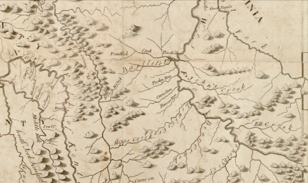
Kentucky maps from these years present something of a mystery involving the location of Harman Station. There are maps which show the station between Prestonsburg and Paintsville, but these maps are distinctly different in appearance. The renderings of individual map makers vary as to the number and location of creeks and major streams, each one seemingly being a modified version of an earlier publication. According to the online collection of Kentucky maps shared by David Rumsey, neither the 1795 Joseph Scott map nor the John Marshall 1807 map show the station, yet a 1794 map by J. Russell does depict it.
Gilbert Imlay was living in London in 1797 when he wrote his book, “Topographical Description of the Western Territory of North America”. Imlay was a colorful character, a Revolutionary War veteran who came to west to make his fortune. [See “Fact or Fiction?” on this website.] Instead, he fled Kentucky one step ahead of the law. His American years are best known for having swindled Daniel Boone out of a considerable acreage of Kentucky land and having been involved in the circular slave trade which operated between the Caribbean and the American east coast. He moved to England once the American legal system proved too uncomfortable. His “Topographical Description” and a second volume, a novel entitled “The Emigrants,” reflected his intense interest in Kentucky. Both were written during his self-imposed exile.[11] There is a most puzzling set of occurrences surrounding the early progression of Kentucky mapmaking, and Imlay’s work is at the center of the confusion.
The map which Imlay used in his 1797 book was not his proprietary work. It was copied from an earlier map. Elihu Barker produced his map of Kentucky in 1793 and it did not show Harman Station. Gilbert Imlay plagiarized Barker’s map and published it in his book without the addition of two intriguing details which came later, reputed silver mines just west of Licking River and Harman Station. How can it be explained that cartographers within just a few years can attribute such unique differences to their work? It certainly was not due to Imlay’s personal research; he never visited any portion of extreme eastern Kentucky. In essence, the original 1793 Elihu Barker maps was the same one used by Gilbert Imlay in his 1797 book.[12] This map, the one Imlay copied and used in his book, does not show Harman Station. There was a later edition of that same map which did depict the station, but who supplied the information necessary for locating it remains a mystery.
[11]Book: Imlay, Gilbert, 1797, printed in London; Topographical Description of the Western Territory of North America. Although his later map shows it, Imlay never speaks of Harman Station in this book.
[12]A map of Kentucky from actual survey Library of Congress (loc.gov) “Kentucky was admitted to the Union on June 1, 1792. In 1793, Elihu Barker created the most accurate map of Kentucky up to that date from actual Survey. It shows the mountains of eastern Kentucky and those between the Cumberland and Tennessee Rivers in western Kentucky and indicates salt licks throughout the state as well as principal trails, towns, and settlements. Among the towns indicated are Washington, Charleston, Lexington, Versailles, Louisville, and Stanford. The map divides Kentucky into nine counties, but it does not show precise county borders. Barker provides useful descriptive notes, such as “fertile high land where it is reported are quantities of stones of a sulphurous effluvia” and “barren naked land.” Barker engraved the map for Mathew Carey (1760-1839), an immigrant from Ireland who in 1795 published the first atlas in the United States, the American Atlas. The map is from the Rochambeau Collection at the Library of Congress, which consists of 40 manuscript maps, 26 printed maps, and a manuscript atlas that belonged to Jean-Baptiste-Donatien de Vimeur, comte de Rochambeau (1725-1807), commander in chief of the French Expeditionary Army (1780-82) during the American Revolution.
William E. Connelley wrote his Harman Station and Jenny Wiley book in 1910 and used this later map as proof of the station’s location. He stated that the one he used was Imlay’s original map, but that was not true. Connelly had ignored both Barker’s original map and the one published in Imlay’s 1797 work and instead used the later version with the addition of Harman Station. To summarize, the locating of Harman Station on a map did not occur until some years after the Jenny Wiley saga ended.
It is therefore natural to be skeptical as to how Harman Station was added to the later map. It may well have been added after the Hanks deposition of 1838-1840 was made public. Unfortunately, what prompted the addition, who decided that it was important enough to justify its addition to an earlier map, and who decided where the station land had been located is yet to be proven. We know that John Hanks’ affidavit stated that a log cabin existed on Johns Creek where Jenny was rescued, and also from John Graham’s testimony that Mathias Harman had a place on Johns Creek, but neither Hanks nor Graham offered documented proof in court.

1793 Elihu Baker Map and the same engraved print Imlay would display on his first published map
1793 Elihu Baker Map without Harman Station
1793 Harris Map
1793 Cyrus Harris Map showing Harman’s Station for the first time a great distance up river from Vancouver.
A Map of The State of Kentucky drawn from the Best Authorities 1793 displays Harman’s Station is located do East of the Great Salt Spring at Fowler’s Lick, located 10 to 12 above the Mouth of Beaver on Salt Lick Creek. This later edition does show it and was used Mary Verhoeff’s 1911 book: “The Kentucky Mountains, Transportation and Commerce, 1750 to 1911”
Court cases have changed what we once believed to be the first documented settlement in the upper Big Sandy valley, which was established by the Adventurers. Harman testified in the McGuire case the 1,283 acres of land known as Harmans Bottom was the first settlement, established in 1789. Harman lived on that land for many years, until 1801, when he located back to Tazewell, Virginia. We also know by deed that Mathias Harman on May 3, 1797 helped to survey Prestonsburg, along with Major Andrew Wood and Solomon Stratton, as Adventurers under the John Preston grant. (Deed Book A, page 166 Floyd County)
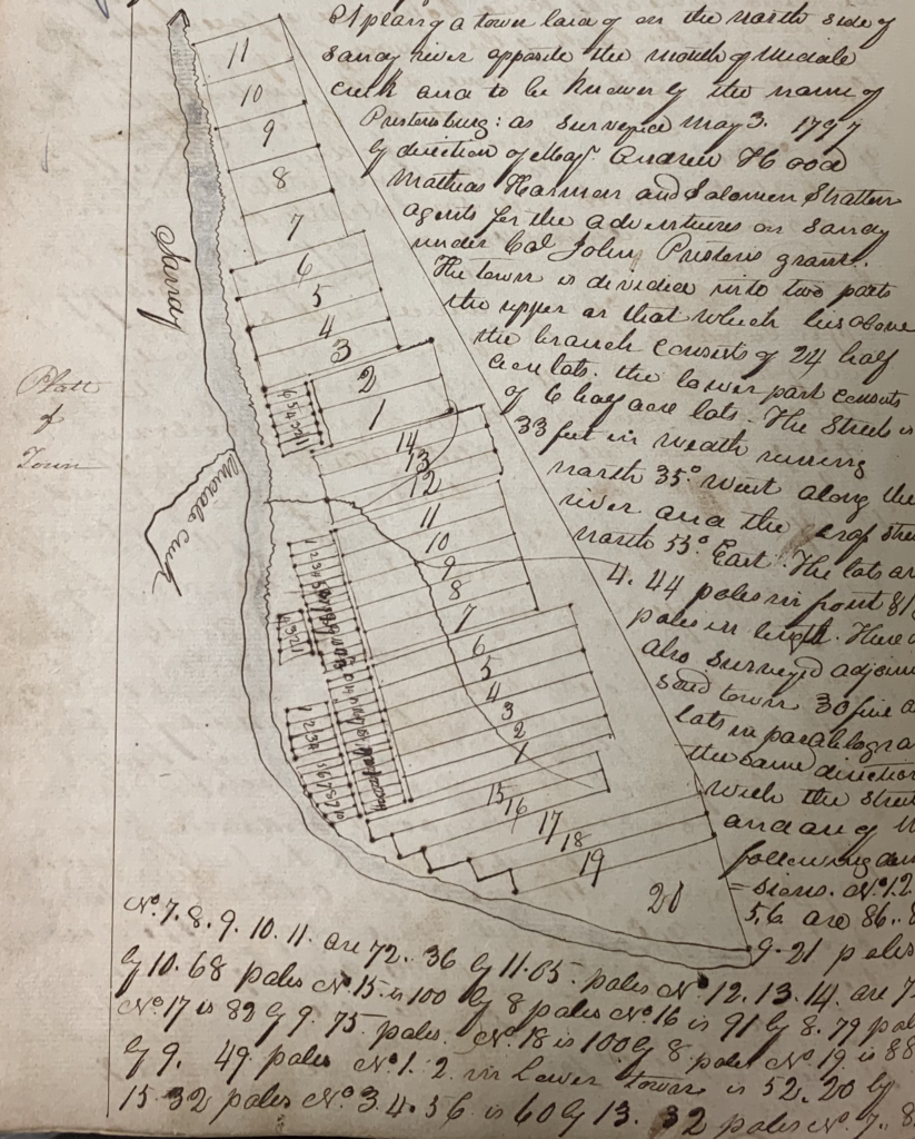
Copy of the original 1797 plat of Prestonsburg, surveyed
with Mathias Harman’s assistance.
Recapping the events proven by these court cases, the Harmans moved back to Tazewell, and the 400-acre tract known as Harman Bottom was sold to William McGuire, then sold to John Hackworth, then to James Honaker. Several lawsuits were filed contesting the legality of the Harman Bottom. There was no deed from John Preston to Mathias Harman, but only a contract. Therefore, Harman, McGuire, and Hackworth lived on the lands a combined near-50 years until the clerk of the county, James Honaker, bought the property. Following his death, Honaker’s heirs in several cases from the Kentucky Archive leave us with that information.
With certainty, and under depositions, the first Harman settlement was in the Big Sandy valley. It was variously known as Harman Station, Harman Bottom, and Harman Settlement. It was established between 1787 and 1789 on 1,283 acres, now in Pike County. All who were legally deposed testified that it was the first real settlement. Hackworth, while owning those 400 acres, called it Hackworth Bottom, located between Cowpen and Mud creeks, but more specifically at the mouth of Harmans Branch.
There is a typewritten case which is well worth reading, the chancery case of Harman versus McGuire found at Virginia Memory: Chancery Records Index in Tazewell County. It has a tremendous amount of information, and a typewritten version will be added to this site for content.
* * * * *
Conflicting versions of the same historical event are normal. Did Butch Cassidy really die in South America? Was more than one shooter involved in the Kennedy assassination? Even with self-proclaimed eyewitnesses, the true details of an event are often left in doubt. The Jenny Wiley story is no different. Did she escape and find refuge along Levisa Fork at Harman Station, wherever it may have been located, or did her path to safety have her following a completely different route?
Regional researchers and authors west of Pine Mountain have almost invariably adopted the outline of the Wiley story in William Elsey Connelley’s 1910 book “The Founding of Harman’s Station with an Account of the Indian Captivity of Mrs. Jennie Wiley and the Exploration and Settlement of the Big Sandy Valley in the Virginias and Kentucky.” This has been the accepted story published by Virgil A. Lewis in his 1889 West Virginia history and cited by Scalf and others. But there was an earlier, much different account, with a much closer potential eyewitness/participant.
In 1906, four years before Connelley’s book was published, David E. Johnston introduced his “A History of Middle New River Settlements and Contiguous Territory.” Being a devoted student of history and having a library that was “one of the largest in the West,”[13]Connelley undoubtedly owned a copy of, and was familiar with, Johnston’s work. Johnston, like Connelley in his later work, had no living witnesses to Jenny Wiley’s capture or escape to interview, but instead depended upon correspondence and historical accounts.
[13] Legends of Kansas.com/William-connelley/
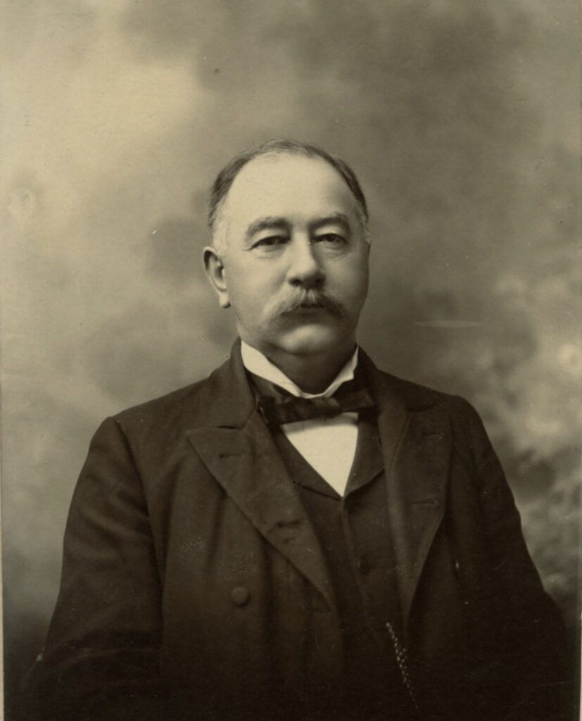
WILLIAM E. CONNELLEY
Virgil Anson Lewis, in his 1889 “History of West Virginia,” page 714, states that Thomas, Jenny Wiley’s husband, was away from home digging ginseng at the time of her capture. Other than that single detail, Lewis basically tells the same story as Connelley.
Both Johnston and Connelley agree on the essential early facts of the story: that Jenny Wiley was captured in October 1789 and taken from her home, along with her children; that the children were killed soon thereafter; and that the Indians and their captive traveled by a circuitous route until they reached Tug River and eventually the Indian town at modern Chillicothe, Ohio. Johnston’s account was based upon his correspondence with a Mr. Armstrong Wiley and a report to the governor of Virginia from Colonel Robert Trigg. At that point, the two stories take totally different paths.
DAVID E. JOHNSTON
(Frontispiece of “History of New River. . .”)
Photo from West Virginia & Regional History Center
Johnston’s story centers around a young man named Samuel Lusk who had been captured in July 1792 and taken to Chillicothe by the same Indians who held Jenny Wiley. This was more than likely the same Samuel Lusk who was one of the 41 signatories to the August 16, 1796 petition to Governor Garrard pleading for protection along upper Levisa Fork.
Lusk and Mrs. Wiley were left in the village under the supervision of an old chief when the warriors formed a September hunting party and headed north. It was then that “Lusk determined to make his escape, and made known his intention to Mrs. Wiley, who declared that she would go with him. He sought to dissuade her as she could probably not keep up with him in traveling. . .” Lusk had played the part of a grateful captive and made it known that he intended to remain with the Indians and become a warrior. Mrs. Wiley, on the other hand, had been under a careful watch due to her “signs of uneasiness and inclination to go away.” As a result, she was “placed in charge of the old Indian Chief with directions to keep close watch on her.”
Johnston’s narrative continues:
“Late one evening near sundown, the old chief, lying on the ground, “required Mrs. Wiley to sit down beside him; he drawing the skirts of her dress far enough towards him that he could lie on the same, which he did; turning his face from Mrs. Wiley, he went to sleep. He had on his belt his scalping knife . . . Lusk made known to Mrs. Wiley that he was ready and about to go and . . . reaching over the body of the old Chief she secured his scalping knife, cut that portion of her dress underneath him from the other portion on her body, and hurrying down to the bank of the Scioto, where Lusk had a light canoe in readiness, they entered the same and immediately and as quietly as possible set off for the southern bank of the Ohio, fifty miles away . . . where they abandoned their canoe.
“Lusk believing they would be pursued, and afraid to follow up the Sandy or Guyandotte waters . . . he steadily kept his course up the southern bank of the Ohio to opposite Gallipolis, where a few French people lived, crossed over into the village and found a place of refuge, where he and Mrs. Wiley could hide away until the danger of recapture had passed.
“Mr. Lusk determined to take no risks by attempting to return through the Virginia Mountains, and finding some men passing up the Ohio in a push boat bound for Pittsburg, he secured passage with them, leaving Mrs. Wiley, who declined to go in the boat, with her kind protectors in Gallipolis.
“In a few days after Lusk’s departure, Mrs. Wiley made up her mind to endeavor to make her way home by the Kanawha and New Rivers, which she did after many days . . . finally reaching her husband’s brother and family at Wiley’s Falls on New River in the now county of Giles, Virginia.”
Samuel Lusk made it to Pittsburg and was back in southwest Virginia a month later. He eventually came to Floyd County, where he signed the above-mentioned petition in 1796. It was at this point in Johnston’s book that he identified one of his sources:
“It was related to the author several years ago by Captain William Stowers, of Bland County, Virginia, then a man above the age of eighty years, but very intelligent, that he well remembered Mrs. Virginia Wiley, who a number of years after her return from captivity visited his father’s house . . . and that her mind was weak, that in fact she had but little mind since her return from captivity, and that he heard her relate to his father and family the story of her capture. . .”[14]
Johnston ended his coverage of the Wiley story with a letter from a second source. This informant, a gentleman named Armstrong Wiley, stated to Johnston “that both Mrs. Wiley and her husband, Thomas Wiley, are buried in the Wiley burying ground at Wiley’s Falls in Giles County.”[15]
Samuel Lusk never sat for an interview and failed to preserve his involvement, if any, in the Jenny Wiley adventure for posterity. If Johnston’s telling of the story is true, Lusk was an eyewitness participant who could have verified the details of Jenny Wiley’s escape. Instead, we are left with conflicting accounts of her determination and flight from captivity.
[14]William F. “Billy” Stowers was born in 1812 and would have been 20 years of age at Mrs. Wiley’s death in 1832. His memory could well have been correct.
[15]Armstrong Wiley was born in 1847, lived in Giles County in 1850 and 1860, and thereafter between Giles and Monroe County, West Virginia. He died in 1932.

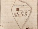
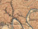
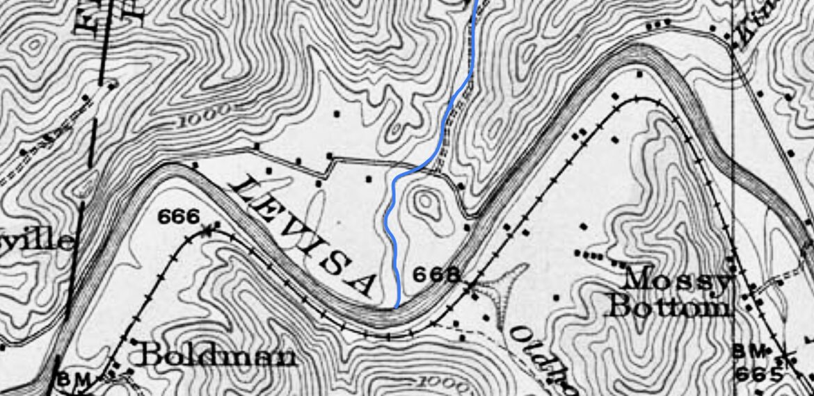
The above image is taken from the Floyd County Court Records Book A, Page 259. The old court ordered plat shows the survey outline of McGuire Bottom, formally know as the Mathias Harman Plantation. The same bearings held true for John F Hackworth land. The lower image is from Harold USGS Topo print 1916, you will notice the Old Ky State Highway. If you ever had a hankering to play a round of golf near Pikeville , you might have putted a few golf balls across these luscious bottom’s known as Harmans Plantation.
Careful researched and written by team effort: Barbara Vance Cherep, Randall Osborne, Kevin Hall