EASTERN KENTUCKY SALT WORKS
Salt was a vital commodity in the Western Virginia Frontier long before Kentucky had became a State. Long Hunters and Early Settlers had the ability to preserve food in an era long before refrigeration ensured its high demand. As important as salt was in the Colonies of North America , it was even more important on the frontier, where access to meat was more limited. Fortunately, salt deposits were quite common on the Eastern Kentucky frontier.
Several large Mineral and Salt Licks were widely noted in Virginia and Old Kentucky land patterns. One of Merry Walker’s surveys dated April 23, 1787, assigning a 5000 acre tract to Rev. John Graig. This patten covered part of Beefhide Creek of Shelby Creek, the long narrow fork was called Lick Branch, a befitting name. Another major Salt Lick was located Salt Lick Branch of Right Beaver Creek, called Fowlers Lick, named after James Fowler in 1775.
However, finding salt reserves (often in ground surface springs called “licks”) and then rendering the mineral into a usable form was as tedious process. In organized operations, when workers located a salt lick, they first drilled through the mud and sand in a nearby creek bed until they struck the salt water. Extracted through pipes, the water was pumped by either man or horse power into large salt kettles. Weighing up to 90 pounds, the kettles were boiled in wood-fired or coal-fired furnaces built on the ground. As the saline water boiled, it evaporated, leaving salt residue behind. This long-drawn-out process often produced an average of 25 to 50 pounds of salt per 1,000 gallons of salt water.
Early Kentucky salt deposits were often found in the Appalachian Mountains of the eastern part of the state. Large operations such as the Goose Creek Salt Works in Clay County provided nineteenth century Kentuckians with the vital product. The area around Lick Fork of the Left Fork of Middle Creek know as Boone’s Salt Spring, was eventually settled by James Young who opened a salt mining business. Salt making was the first industry of Perry County. A road survey court order of January 28, 1817, mentions salt works on the North Fork of the Kentucky River.
Youngs Salt Works
The original discovery of the Young’s Salt Works: As the story have been told, Daniel Boone at the age of thirty-three, Daniel Boone made his first trip to Kentucky, arriving in the Big Sandy Valley in the winter of 1767-1768 with his brother, Squire Boone, and William Hill. Boone’s venture into the Big Sandy Valley was his first of many trips to Kentucky, but he wouldn’t return to the Big Sandy until about 30 years later. He told his children that he first heard of “Kanta-ke” while serving as a teamster with Braddock’s army in 1755. He had been influenced by the talk of fellow soldiers especially by James Findley-about the bounty of the western lands. In 1753, Findley had made a trading expedition to the “Blue Lick Town” of the Shawnee located on a fertile plain near the large salt licks that gave the Licking River it name. Findley reported that other Pennsylvania traders were also in the region at that time.
The Boone party crossed the Appalachian ridge to Russell Fork of the Big Sandy and followed the river’s northwestern course, which they reasoned, must eventually lead them to the Ohio. They passed the rim of the “Breaks of the Sandy” and followed a buffalo trace over fifty miles to a large salt lick at present-day David, a few miles west of Prestonsburg. 30 While they were camped at the lick, Boone is said to have killed his first buffalo, and feasted on its liver and roast hump. Daniel’s son, Nathan, later wrote, “they ware ketched in a snow storm and had to Remain the Winter.” Boone and his companions returned to their home in North Carolina in the spring of 1768, disappointed that they hadn’t found the “land of cane and clover” promised by Findley.
The operation finally became known as Middle Creek Salt Works. The salt mined from this location was sold to early pioneer settlers and was later used by both Union and Confederate soldiers during the Civil War.
Nathan Boone Visit
According to Nathan Boone, Henry Lee commissioned Boone to survey a large tract of land on Blaine Creek in October 1796. They left their cabin with some chain carriers and were joined by two young men from nearby Paris who wanted to go along for an excursion in the woods. The party traveled up to Limestone where they hid the canoe and proceeded several miles up the creek to begin their survey. It took a few days longer When they returned to the canoe, they enjoyed having some apples and a bottle of Old Monongahela they had purchased from a boat on their journey up the Ohio. Nathan humorously added that their traveling companions “ate plentifully of the green apples with a generous amount of old Monongahela and got quite sick.” No record has been located in the Kentucky Land Office of this survey by Daniel Boone.
Later in the fall of 1796, Nathan headed up Licking River on a bear hunt with his father, Flanders Callaway—husband of his older sister Jemima-and a few others. They rode their horses as far as Burning Springs at present-day Salyersville and headed over the mountain towards the Big Sandy. After killing only one bear, two of their companions got discouraged and returned home. The party continued on to a settlement with three or four families and a few work hands at Young’s Salt Works— present-day David at Lick Fork on the Left Fork of Middle Creek. They also stopped a few miles downstream at what Nathan call the lower settlement on the river—present-day (West) Prestonsburg. They didn’t venture far up the Big Sandy but did meet a man that told them bears were on a creek about nine miles down the river. They went there and killed about forty bears by the end of December 1796 on a stream that became known as Greasy Creek. They saved the bear skins and smoked the meat, then made a large canoe and floated it down the river to Limestone. Daniel and Nathan returned by land with the horses. The meat was hauled over from Limestone to Bourbon County, where they learned it was more valuable if rendered into oil. An adult bear carcass would yield ten to twenty gallons of oil that would sell for a dollar per gallon.”
How the Young’s Salt Works started, its beginning starts with Virginia Treasury Warrant No. 9912 issued to Elias Edmonds in December,1782. Elias Edmonds held the title Lieutenant Colonel, in the Continental Army during The Revolutionary War. For his war efforts Elias Edmonds was given a Treasury Warrant for a bounty of land for his choosing providing a land survey would later accompany warrants. But instead, Elias Edmonds chose to assign Treasury Warrant to fellow Patriot Col. John Green from the Virginia 6th Regiment. Both Lt. Col. Elias Edmonds and Col. John Green would fight under George Washington’s command.
This next section explains how Treasury Warrant No. 9912 was broken into four surveys. Information and Research provided by Fred May ” Surveying the Big Sandy”.
In January 1796, Henry Lee sent Samuel Plummer up the Big Sandy Valley to survey four tracts of land for John Green.44 The family of James Young resided in the area, so Plummer enlisted him as marker for the surveys and James Young, Jr. and Patrick Young as chain carriers. The first two surveys (OK-1610 and OK-1611, for 1,000 acres each) are dated January 4, 1796. They note painted trees in the area, name early routes running through the area, and OK-1610 became the subject of subsequent court actions. The descriptions in the surveys makes their exact locations problematic. However, a study of other documents places them on Middle Creek—west of present-day Prestonsburg-and gives evidence that OK-1610 • contained what became known as Young’s Saltworks. Plummer’s description of the survey makes no mention of the salt lick, but other evidence places it near the northeast corner of the tract in present-day David.
Another survey OK-1611 begins at: “an elm tree painted black at the fork of the Shawnee road, one of them leading to Clinch and the other to the Cherokee Nation, about 20 miles from the Big Paint Lick.” OK-1610 is about 6 miles upstream from OK-1611 and begins: “at the forks of a creek on the left hand road leading from Sandy to Clinch at a beech in the forks of the creek…
Plummer’s next two surveys (OK-1612 and OK-1613, for 1,091 acres each) are dated January 12th. They begin about 15 miles south of OK-1610. Both are described as: “being in the County of Mason on the waters of Sandy and a branch called Bevor Creek.”
These are the first surveys known to mention ‘Bevor’ (Beaver) Creek. Other records credit James Fowler for naming the creek in 1775.* Eleven surveys had been run on the creek as early as 1785, which is described as “a larger South fork of Sandy that heads nearly with the head of Licking.” A study of the survey descriptions places these two tracts near the southern tip of present-day Floyd County in the vicinity of Melvin and Weeksbury, where the road leading from Sandy to Clinch crosses the mountain to Indian Creek in Pike County.
About three months prior to the dates of the surveys, John Green assigned rights to the entries for all four surveys to James Young. The assignment was again certified by Green in March 1796, when Young assigned half to John Breckenridge. Patents for three of the tracts excluding OK-1610, as explained below-were issued to James Young and John Breckenridge in November 1796.
Robert Johnson was in the area during the same time Plummer and his crew were running their surveys. He made a survey dated January 13, 1796 for Benjamin Netherland (OK-1715 for 192 acres). This tract begins near a salt spring “on Salt Lick Fork, a branch of Big Sandy Creek.” On May 23, 1796 Netherland filed a caveat against James Young and John Breckenridge for their survey of 1,000 acres (OK-1610) run for John Green on January 4, 1796 and assigned to Young and Breckenridge. The Netherland survey was made by virtue of an entry in Fayette County dated November 29, 1782—predating Green’s entry by about two weeks. Netherland asserted that his survey was within the boundary of their survey and was valid because it had the earliest entry date. On June 17, 1796 Netherland assigned half of his survey to Johnson On August 24, 1796, “in pursuance to an order from the worshipful Court of Mason County,” a party of men met at the supposed site of the Netherland tract to depose William Thornton, who was called to give testimony: “to establish the beginning of an entry made in the name of Benjamin Netherland of one hundred and ninety two acres which entry calls for to include a lick called Fowler’s Lick.”
Fowlers Lick on Saltlick Creek
Thornton a noted Long Hunter, said he first visited this site in December 1775 while on a bear hunt with James Fowler and William Pitman: “Mr. Fowler came first to the lick and told us that he had found a lick and we came up and looked at it and at that time Fowler called it his lick as he was first at it.”
Thornton was questioned by two attorneys, Robert Johnson and John Breckenridge-both principals in the case. The place where they met was:”a salt lick on a branch of Sandy called Fowler’s Lick and now occupied by James Young.” Johnson asked a few questions confirming the distance Thornton had traveled to the lick in 1775 and the names of other men that had come from Clinch who knew it by the name of ‘Fowler’s Lick.’ Thornton also confirmed he was aware of ‘Big Paint Lick near Sandy’ being about 20 miles from the location of the Young and Breckenridge surveys, and that he had never heard of it being called Fowler’s Lick.
Then John Breckenridge began to ask for more details. Thornton told of being with a few other men at the lick in March (1796) to get salt and that his bear hunting trip with Fowler and Pitman was made: “about the first of December 1775 and we returned back again the day before Christmas.” He explained that their route started from home at Castlewood on Clinch River—: “and came out through Little Paint Gap … and came down Shelby Creek … then took an old Indian track and kept along under the dividing ridge on the waters of Sandy, then left the trail and camped on a creek that Fowler called Beaver Creek. “
Saltlick Creek, which flows into Right Beaver at present-day Bosco-Hueysville P.O.—about seven or eight miles upstream from the confluence of the main forks of Beaver Creek at Martin. This is the location of a saltlick mentioned earlier in this chapter regarding the controversy over the location of Fowler’s Lick. William Thornton and Philip Roberts are known to have been there on a hunting expedition as recent as March 1796, making salt for settlers at Castlewood on Clinch River. Skinner assigned the survey to Ralph Morgan, who was familiar with land in the area since he had run surveys there in the mid-1780s—as a deputy surveyor in Fayette County-for George James and John Tompkins.
William Johnson, deputy surveyor of Mason County, went to the lick in October 1797 to re-survey the tract for Benjamin Netherland (OK-3875 for 192 acres) ‘on Salt Lick Creek, a branch of Big Sandy. ‘ It was run on the same entry as the one used for OK-1715, with only minor differences in a few calls. No patents are filed in the Kentucky Land Office with either of these surveys for Netherland. However, OK-1610 was patented to Young and Breckenridge on April 4, 1798, so the caveats were apparently resolved in their favor.
A small square survey—80 poles on each side—was run along the creek in late October by Andrew Woodrow for George May (OK-4965 for 40 acres) and was patented to him in June 1801. Samuel McMillen, Esq., was the “Marker, Pilot & Director of the Survey,” and the chain carriers were Wm. Axier and Samuel Thumbmer. This survey was run on the first entry made for land in the Big Sandy Valley: “…on a Southwardly branch of Sandy Creek to include a very large Sulphur Salt Lick on the west side of said creek very much frequented by Buffaloes.”
There were at least two known licks on Right Beaver Creek. One was on Saltlick Creek as noted above. It is assumed that George May’s tract is the one a short distance upstream from present-day Maytown-about halfway between Martin and Garrett.
Facts still surrounding these surveys add to the unresolved mystery of the location of Fowler’s Lick today. The first record of a lick with that name is denoted on John Filson’s 1784 map of ‘Kentucke’ on Gr. Sandy Cr. The map shows the lower end of the Big Sandy at its mouth on the Ohio River, and Fowler’s Lick is the only landmark on the stream. The 1796 deposition of William Thornton and information in surveys and caveats filed by James Young and John Breckenridge place Fowler’s Lick on a fork of Middle Creek. At the time of the deposition, that site had become known as Young’s Saltworks. Thornton said he knew the location of Big Paint Lick and never heard of it being called Fowler’s Lick.
Scalf wrote that high up on a mountain on the old Allen farm on Gosling Fork of Right Beaver Creek is
‘Daniel Boone Rock, inscribed ‘D.B. 1775. If this is an authentic date, Boone would have been there very early in the year since on March 10t he began blazing a trail along the ‘Wilderness Road’ over Cumberland Gap to the Bluegrass of Kentucky.’ The farm was owned by George and Cynthia (Patton) Allen Scalf also tells a story about James Fowler, William Thornton and William Pittman discovering a salt lick near present-day Hueysville on Right Beaver Creek He credits Fowler with naming the creek for the abundance of beavers along the stream. Other accounts of the location of the salt lick these men visited place it on the Left Fork of Middle Creek at present-day David explained. Henry Scalf, also aware of information in William Thornton’s deposition, agin concluded that Fowler’s Lick was located at present-day Hueysville on Right Beaver Creek—not at David on Lick Fork of Middle Creek, just a short distance from the home of Reuben May, the brother to Thomas May Sr. of Shelby Creek. This local establish town is known today as Maytown. Reuben May married the daughter of George and Cynthia Allen, shown living Floyd County Census in 1830
Goose Creek Salt Works
Clay County, Kentucky was formed in 1806 and established in /1807 from parts of Floyd, Knox and Madison Counties. A number of accounts of the history of the county, written over the past 150 years, relate the significance of salt making to the early development of this remote section of Southeastern Kentucky.
In 1847, historian Lewis Collins wrote of Clay County in his History of Kentucky!
“Clay County lies on the south fork of the Kentucky River. The face of the county is generally hilly and mountainous —the principal products, corn, wheat and grass. Coal is abundant and is used by the inhabitants for fuel. Salt is manufactured at fifteen furnaces in the county, producing from 150,000 to 200,000 bushels per annum, and of the best quality. About nine miles from Manchester, there is a spring which produces an abundant supply of gas.
Goose Creek Saltworks
Early Goose Creek Saltworks one of the earliest accounts of manfacturing salt on Goos Creek are found in three articles reprinted by Jess Wilson in small pamphlet obtained from the Clay County Genealogical and Historical Society; “Salt Making in Clay County, Kentucky: The Rise and Fall of our First Industry
A 1927 article published in the Filson Club Quarterly tells some colorful stories of the end of the Eighteenth Century when James Collins crossed over from Virginia into Eastern Kentucky with a party to hunt in the region of present-day Clay County.’ On a creek later known as Collins Fork of Goose Creek, Collins chanced to find a spring whose waters were unusually salty. He returned to Virginia to organize a pack train of men and mules to haul food and other supplies, along with a number of large cast iron kettles, into the remote region and soon began to manufacture salt. Ingredients used in the process included crushed lime and the blood of hogs and cattle which were added to the boiling kettles when the brine was being finished to insure proper texture and whiteness in the finished product.? The salt was packed in casks made of oak staves and hauled by pack mules to scattered settlements in Kentucky, Tennessee and Southwestern Virginia. Merchants from Lexington and Knoxville and smaller settlements also came by ox-drawn wagons, bringing flour, dry goods and other merchandise to exchange for a precious cargo of salt. An old ledger was referenced in the article, with entries of hides, furs, skeins of thread, flour, whiskey and other commodities being traded for Clay County salt.
As it became apparent that the Collins’ business was profitable, other men came into the region to claim land with underlying salt water, drill wells, and enter into their own enterprises, competing very vigorously with Collins and each other. The article goes into detail about the methods for drilling wells to reach the veins of salt water deep below the surface and tells of huge wooden pumps that drew the water into troughs made from halves of yellow poplar logs, then sent through drilled cedar pipes to evaporating pans. Furnaces were built on site in a trench lined with stones and mortar, forming a horizontal chimney that was fed on one end with a fire of wood —and later coal.
Transportation of salt to Central Kentucky was facilitated by freight boats running down the Kentucky River. During low tide the boats could only be moved down the shallow tributaries of the river with poles pushed from a walk-way along the sides of the craft.
During high tide, very little poling was required and long oars served to steer the boats downstream, but particular attention had to be given to shallows and sharp bends. A treacherous shoal on Redbird Creek, known as The Narrows, was said to have been the scene of many disasters.
A 1952 article by Roy R. White adds to the above account, telling that James Collins’ saltworks were located at the mouth of White’s Branch on Collins Fork of Goose Creek some time before 1790.’ White relates that Collins’ site wasn’t a “regular” establishment until it passed into the hands of Alexander Outlaw some years later and asserts that Samuel Langford was the first man to start the salt-making industry in Clay County at his lick near the present site of Manchester. He states that “Collins made salt only for his own use, whereas Langford manufactured it for sale.” About the time Langford was building his salt works, a furnace was established at Collin’s Lick by Alexander S. Outlaw. Soon afterward he sold it to John Ballinger, who in turn passed it on to Colonel James White of Abingdon, Virginia2 3 In 1802 the Kentucky Legislature directed that roads be improved to reach Langford’s Lick and Outlaw Salt Works.
Additional research shows that on February 6, 1804, John Ballinger sold a fourth interest in 400 acres on Collins fork of Goose Creek plus full interest to another 400 acres to James White, a merchant in Abingdon, Virginia. Payment of about $1,550 was made to Ballinger in merchandise from White’s store. The first tract included the “salt works now occupied by Alexander Outlaw, Sr. & John Ballinger. . . and all kittles, buckets, troughs, oxen cart, etc.” In 1806 James Kincade (sic) sold a tract of land to James and Hugh White for $250. The deed —with a note that Hugh White was living on the land at the time— wasn’t filed until Oct 9, 1822 Ballinger and his partner were in business and he was willing to sell his interest in the business for credit in Abingdon, a southwestern outpost in Virginia that was a trading center for settlers of the remote Eastern Kentucky valleys. For many decades the names of Ballinger, White and Kinkead appeared in subsequent deeds along the creek. Hugh White, a brother of Colonel James White, came to Kentucky to take charge of the Outlaw furnace and later bought it outright.
Later he turned it over to his son, Alexander, and established another furnace near his home. Two more sons of Hugh White, James and Daugherty, and their descendants, continued to own salt furnaces four miles up the East Fork of Goose Creek as late as 1885. This property was once owned by Reuben May.
Mrs. Bessie White Hager, daughter of Daugherty White’ and granddaughter of Hugh White, wrote another account of salt making in Clay County? She claims that James Collins came to the region in 1798 and first became aware of salt on Collins Fork in 1800. She adds that her grandfather’s brother, Col. James White, was quartermaster of the army of General Cox of Tennessee, who was responsible for protecting white settlers of the frontier. The Colonel learned of Collins’ salt springs while in Lexington securing supplies, purchased some land in Clay County, and formed a partnership with Hugh in 1804. She claims that the salt furnace built by her grandfather was the first in Kentucky and adds that Col. White paid for the property with merchandise delivered to Barboursville from Baltimore, Maryland.
Hugh White operated a number of salt furnaces in the county during his lifetime.
Salt Manufacturing Ventures of Reuben May
The May Historians and Clay Countians know about Reuben May’s ventures in the business of manufacturing salt in Clay County from a number of deeds and pleadings of law suits filed in the county over a period from 1850 to 1867. When Reuben arrived in the county in 1849, he must have had a significant amount of money —and even better credit— to invest. Before he committed to move his family from Pike County, Reuben apparently had made arrangements to invest in the salt business with a few other investors. He became the managing partner of operations on a large tract of land on the southeast fork of Goose Creek —about eight miles from Manchester— and resided at Mt. Welcome. About the time Reuben arrived in the county he entered into the partnership of Blackburn, May & Kinkead. Soon afterward he formed Apperson, May & Co. with Richard Apperson and Judge William B. Kinkead. Churchill J. Blackburn resided in both Knox and Clay Counties; Kinkead in Kenton County, across the Ohio River from Cincinnati; and Apperson in Montgomery County.
In order to better understand Reuben’s business ventures in the 1850s, it is beneficial to study the difficulties that prior owners and managers had faced. The first partners to invest in the salt business where Reuben settled were John C. Wilson and Gustavus B. Quarrier.
A summery of the experiences of the Wilson & Quarrier partnership, beginning in 1832, is given in the Appendix. By January of 1841 Wilson & Quarrier were in arrears on mortgage payments to the partnership of Blackburn & Kinkead ($2,500) and to other creditors represented by Frank Ballinger ($15,000). The Clay County Sheriff was authorized by Clay County Circuit Court to seize the properties.
It was stated that Reuben May borrowed money to keep salt works operational from his father Thomas May. Below a promissory note dated Oct 29, 1856, Reuben May received a loan for $1600.

The Image in the Floyd County Court Order Book shown below is not placed out of order, but is clearly shows a public road maintained by one of the Hamilton boys. A name that is shown highlighted besides Thomas Hamilton is George Tackitt. This George Tackitt is possibly the natural brother of William ( Preacher Billy) Tackitt. Preacher Billy Tackitt is found living on Shelby Creek in the 1820 Census, and noted as well in in Lawsuit between Patrick Johnson and Micajah Collier, Floyd County Court Records 1817. Patrick Johnson purchased this property originally from Corbin Thompson, clearly Thompson did not have clear title when he conveyed the land tract to Patrick Johnson, then Patrick Johnson conveys the Robinson Creek tract to Micajah Collier Also noted in Depositions from this particular land dispute, it discusses property boundaries that Micajah Collier purchased from Patrick Johnson clearly overlap land owned by George Tackitt from a previous sale from Richard Damron. Noted in the deposition was the improvement originally purchased by George Tackitt, was a Grist Mill, house, fence and orchards. Lawsuit was finally settled by Patrick Johnson having give back Micajah Collier’s $50 and a horse. After appeals court ruled against Patrick Johnson and sent back to Floyd County Court.
Floyd County Court Order Book B, Pg. 232

You will notice there is an entry in the Floyd County Court Order Book dated September 2, 1813 appointing Thomas Hamilton survey a road from Floyd County Courthouse to Young’s Salt Lick on Middle Creek. Actually a road survey consist of hard labor, working long hours to maintain a good navigation for Floyd County County Road System. A George Tackitt is noted in survey, this could easily be a brother of William”Preacher Billy” Tackitt, because George Tackitt the son of Preacher Billy Tackitt would only be around 10 years of age.
John Graham was deposed in this lawsuit, question by the defendant: Do you know the land that Thompson lived on that lies on Roberson Creek Ans: about the year as 1 can recollect of 1812 I surveyed the land Corbin Thompson lived on. … I was employed to survey the land by Richard Damron and Moses Damron who said they claimed the same by purchase… 2″ day of May 1820 came Moses Damron before me James Roberts.
The George Tackitt tract on Robinson Creek was sold to Thomas May May 20, 1823.
Alexander Patrick’s Salt Works
The first post office in Perry County was located at Alexander Patrick’s Salt Works in 1822. In a mortgage of 1832-1834 he mentions his “bored salt well and 55 kittles” on it. The court records show that in 1833 he had a grist and saw mill on Troublesome Creek. In the November term of court in 1836 it was ordered that a road be surveyed from Patrick’s salt works to the mouth of Troublesome Creek and in 1836 he received land grants on Lost Creek, Lost Fork, Caney Creek and Troublesome Creek. Therefore, from the above information his salt works must have been located near the mouth of Troublesome Creek which was then Perry County. A settlement was already on Troublesome Creek when Perry County was formed and it is reasonable to believe that the post office and the salt works were both located at that point.
It is fairly certain that Henley Haddix owned the works on Troublesome Creek which were situated one and one-half miles upstream near the mouth of Lost Fork, since the Haddix family has always lived in the area surrounding the mouth of Lost Creek. A motion was made in Perry County Court in November, 1832, to change the road to run from the mouth of Troublesome Creek to Henley Haddix’s Salt Licks “as it would be a great convenience to the people traveling there to get salt.” In 1838 this well had a daily capacity of ten bushels. The brine obtained at 240 feet produced a bushel of salt from 100 gallons of water. This is probably the establishment referred to in the census of 1840 as in Breathitt, with a production of seventy bushels and three men employed.
In September, 1833, the court ordered that a road surveyed from the mouth of Troublesome to George Calimeese’s salt furnace. This was to include all the land from the mouth of Francis Branch, and all the land on both sides of the river, to the upper end of Joseph Spencer’s field.
In 1836 the Kentucky House Journal (3) refers to a number of salt works then operating in the Kentucky River Valley, among which were two located near the mouth of Lick Branch and one near the mouth of Troublesome Creek.
Also mentioned in the 1836 House Journal was one salt works at the mouth of Leatherwood Creek and a well partly bored at Hazard. Elijah Combs owned the well at Hazard. It was located where the Central Hotel now stands and the furnace and kettles for boiling it down were in the lot beside the hotel. An excellent brine was obtained at 400 feet, yielding a bushel of salt from 85 gallons of water but “the manufacture was short-lived because of local competition.”
The works at Leatherwood were opened in 1835 by General White and Colonel Brashear and for a time produced 250 bushels a week, which was considered ample for local demand. In 1838 there was a capacity of fifty bushels a day and sufficient water for a yield of three times that amount. In 1840 it represented a capital investment of $18,000. Eleven men were employed and there was an annual output of 7,000 bushels.
Brashear’s Salt Works

In 1854 salt was reached at the mouth of Leatherwood at 100 feet, but not very strong; the borings were afterwards sunk by Brashear to 410 feet, at which depth a fine brine was yielding, when economically worked, a bushel of salt from 65 to 70 gallons of water. (4)
W. J. Cope owned and operated one on Troublesome in 1860.
Mr. Ward and Wiley O. Davis went to Lost Creek in Breathitt in 1860 and made salt. Mr. Ward sold his interest to Mr. Davis and went back to Virginia, as talk of war began. Mr. and Mrs. Walter Nichols had salt works on Leatherwood about this time.
These establishments on Leatherwood and Troublesome were opened occasionally until the railroad came into the valley, but the production was never more than sufficient for local demand. Until the railroad reached Jackson, the price of salt in this section was at times one dollar a bushel.
[History of Perry County]
SHELBY CREEK SALT WORKS
Not long after the murders of Col. David Morgan and his son William Morgan. The Court appointed trustees and guardians of the Morgan’s children, started piece milling the massive lands the Morgan’s had accumulated, including David’s living widow Anne. Anne Morgan would later take comfort in arms of Jesse Adkins and later marry him. They would reside near the mouth of present-day Greasy Creek, not too far from the Forks of the Levisa and Russell River.
On January 29, 1818, on of those Heirship Tracts of William Morgan would be sold by Willian James Mayo the Guardian of his esate to benefit his Heirs. The result of the sale would make Meredith Collins the proud new owner of a 30 acres tract of land on the upper end of an old John Preston survey. This would be part of the 260-acre survey on Shelby Creek. Jonathon Mayo was the Deputy Surveyor, chain carriers were Abram Beavers, Lazarus Damron and Map Maker is none other than Richard Damron.
Sixth day of August 1819 Meredith Collins and William Tackittt had entered into an Agreement. This agreement stipulates that said William Tackitt and Meredith Collins were bound by a signed contract to bore for Salt Water and the said Meredith Collins both bind himself and heirs to lens one good constant hand and to work at said business during the time of the working at said business also to furnish said Tackitt with all spare provisions that he can spare from his own farm by use and to furnish said Tackitt with one-half iron and steel that may necessarily require about the Lick (Salt Lick) for his part for a supporter the said Tackitt to carry on the said business and the said Tackitt both himself and his heirs and company to go with the securing business himself and to superintend and carry to the occurring business on a moderate scale of expenses as possible and to continue boring at all convenience opportunities and to continue till Salt Water is got of both parties agree to quit then both parties to -any up equal parts in all expenses which may occur to preparing and manufacturing Salt and Company, and both parties to go equal parties in all precepts which may arise from the manufacturing of Sale and neither part to sale more take in a partner with our consent of the other parties for the true performance. Both parties bound themselves with a payment to the partnership for the sum of Ten Dollars.
[Floyd County Court Clerk Deed Book B, page 65]
Twelfth day August ,1819, Meridith Collins would convey his land holdings of 30 acre salt tract on the Shelby Creek to William Tackitt for $30.
[Floyd County Clerk, Deed Book B, Page 66]
By a Legislative Act, Chapter 127, 1825, page 123. The Commonwealth Kentucky General Assembly. This Act prohibited the appropriation of a part of the vacant in this commonwealth. That it shall not be lawful for any person to appropriate any part any part of Two Thousand Acres of land on Shelby Creek in Pike County, around the spot where William Tackett (spelled), Jesse Hamilton, and Meredith Collins are boring for Salt Water, the lines are to run to the cardinal points, until after the first day of January, On Thousand Eight Hundred and Thirty, under or by virtue of any law of this state for the appropriation of vacant lands. Provided however, that nothing in this act shall prohibit appropriating the aforesaid land, or any part there.
Approved, December 21, 1825.
March 27, 1828… After nearly ten years producing an unknown numbers of bushels salt at the Old Shelby Creek Salt Works, up steam, just a little above Bartley Hollow. William Tackitt up in years decides he does not want to be the biggest salt supplier on Shelby Creek anymore. The new potential buyer is none other than Thomas May. Thomas May is buying one of the best, salt producing wells in Pike County, Kentucky. The 30-acre tract the well property set on; its description is not hard to follow. Beginning at two sugar trees on the most Northardly (spelled) bank of said crick (creek), thence South 13 degrees; West 40 poles to a Cedar under a cliff, South 88 degrees, West 38 poles to Two Beeches branded B. South 50 degrees, West 10 poles to a Beech, South 34 degrees, West 162 poles to a Beech, Maple and an Ash. Thence Southward by crossing the creek on a direct line to a Spruce Pine, North 3 degrees, West 100 poles to a stake, thence crossing said creek, down with the different demanders (meanders) of said creek, to the Salt Well, thence six poles to a stake; thence down with the different demanders (meanders) center of said Crick (creek) opposite to the beginning; thence Northhardly a direct line to the beginning
Signed: William Tackitt
[Pike County Clerk, Deed Book A, Page 332]
This indenture made and enter into this 14th day of May between Henry B May and Thomas May of the County of Pike and the State of Kentucky of the first part and Leonard Kinney of the County of the state aforesaid of the other part. Land located of Pike on Shelby Creek and bounded as follows to wit Beginning at two sugar trees on the most Northerly bank of Shelby Creek thence S.13’W.40 poles to a cedar under a cliff, thence S.88W.38 poles to two beeches branded B thence S. 50 w.10 poles to a beech S.34 W. 162 to a beech, maple & ash, thence Southward and by crossing the creek on a direct line to a spruce pine S 3 w. 100 poles to a stake thence crossing said creek down with different measures of said creek to the Salt Well thence W. 6 poles to a stake thence down with the said opposite to the begging.
[Pike county Deed Book A1, pg. 259, dated August 7, 1832]
The First Kentucky Geological Survey made by David Dale Owens, one portion conducted during the years of 1854 & 1855. The report was published in 1856. David Dale Owens extensively discusses the time conducting coal measures on Upper Kentucky River and Upper Louisa (Levisa) River. David Dale Owens while studying the confluences where the major heads of both rivers joined at Sounding (Pound) Gap, Owens apparently enlisted the consultation of Capt. May who constructed the road through Sounding Gap. Most locals had spoken of Thomas May as a large land owner on Shelby Creek and a business entrepreneur in Pikeville as well. One of the discussion Owens had with Thomas May was about a two-foot coal bed that was on fire just above the creek on Shelby, the fire had burning for two years, the smothered combustion had produced a kind of natural coke. Owens noted that he had taken samples from this coal bed, he commented on its worthiness and was comparable the natural coke of Virginia.
During this investigation David Dale Owens while in conversing with Thomas May. Efflorescence of salt had shown themself for several miles on Shelby From of the Big Sandy River; this, together with stories of noted Buffalo Licks, led to belief from earlier settlers that salt could be optioned by boring deep into the licks. Boring for salt waster was attempted for nearly 40 years, starting the Tackitt, Collins and Hamilton ventures on Shelby Creek. Several attempts were probably made by Thomas May in search for heavy salt water. The last attempt was noted by Owens, stated by May. After reaching a Dept of 100 feet and forty feet the auger started getting fast, and boring was discontinued.
USGS TOPO PRINT 1916
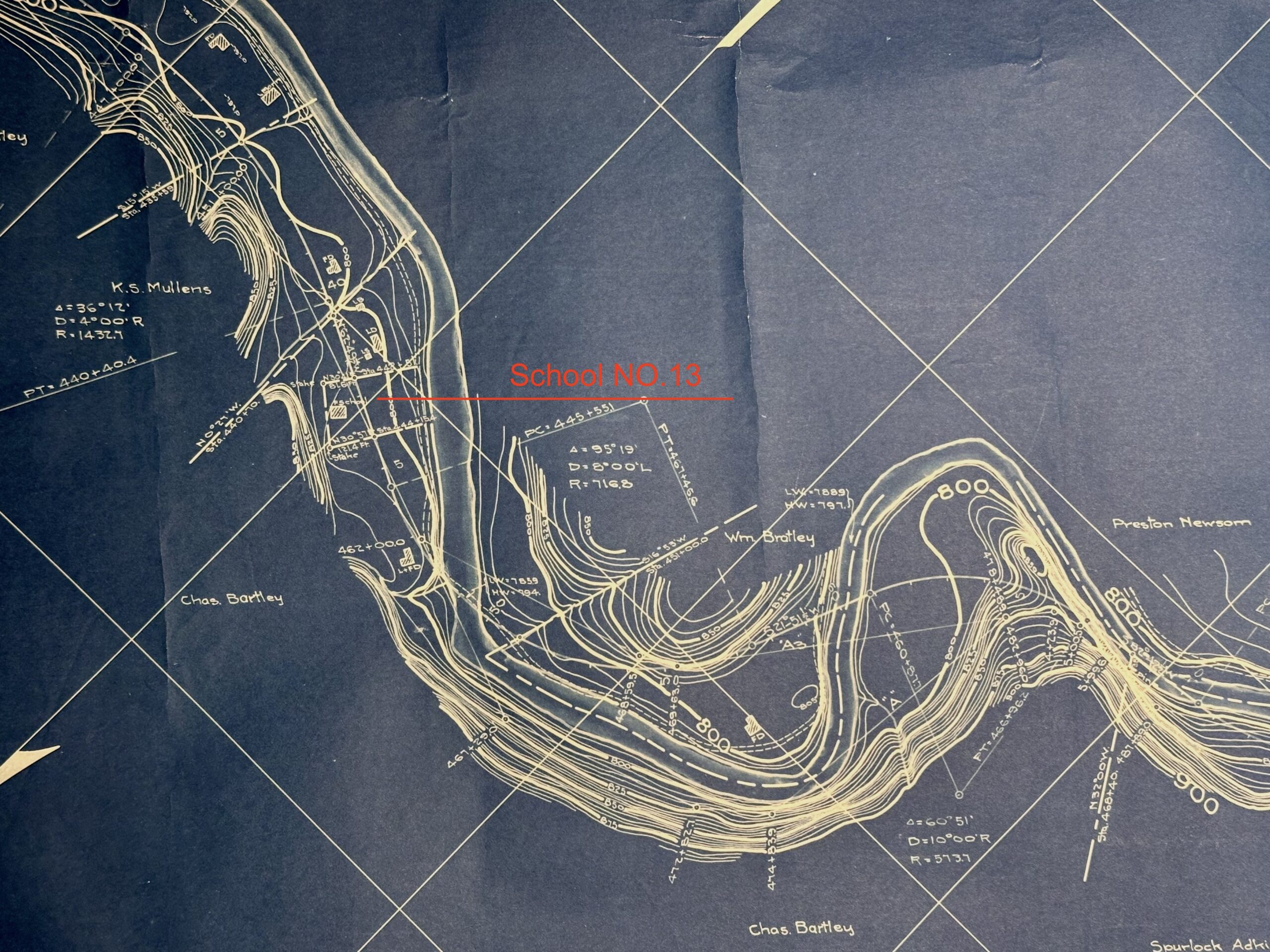
Sandy Valley & Elkhorn Railroad Right Of Way Map 1913
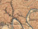
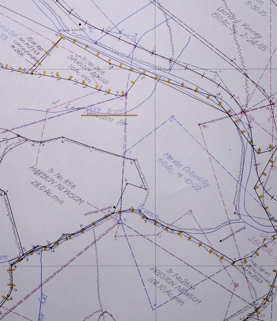
Lick Branch located just below the Mouth of Caney Creek

This Lick Branch located 1/8 of mile above Shelby Creek Salt Works

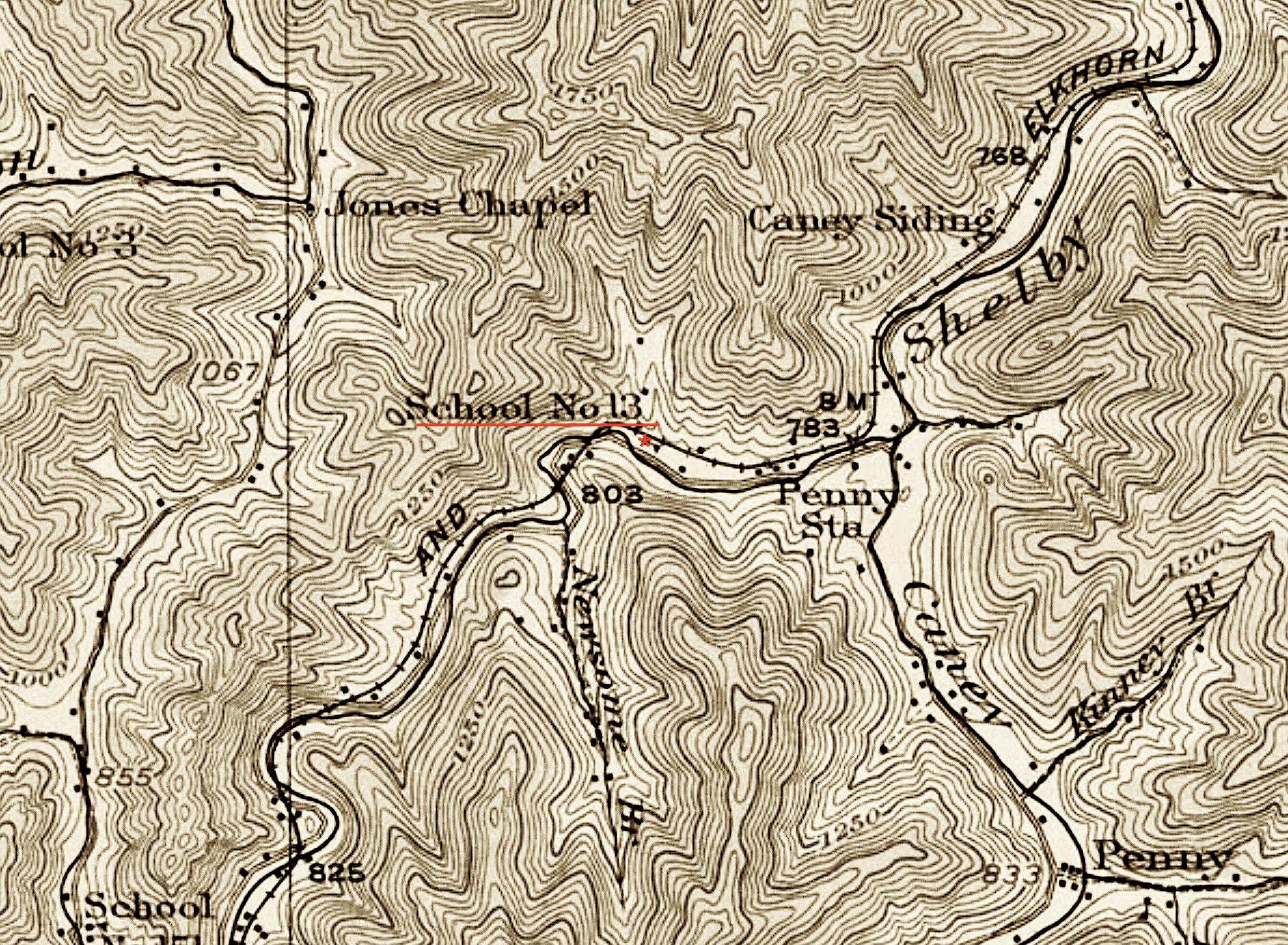
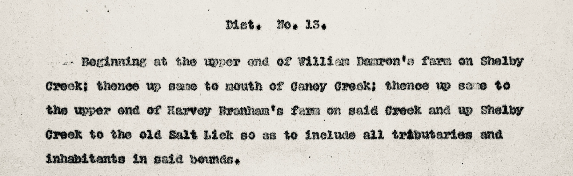
Natural Gas Wells Near Pike County School District No. 13
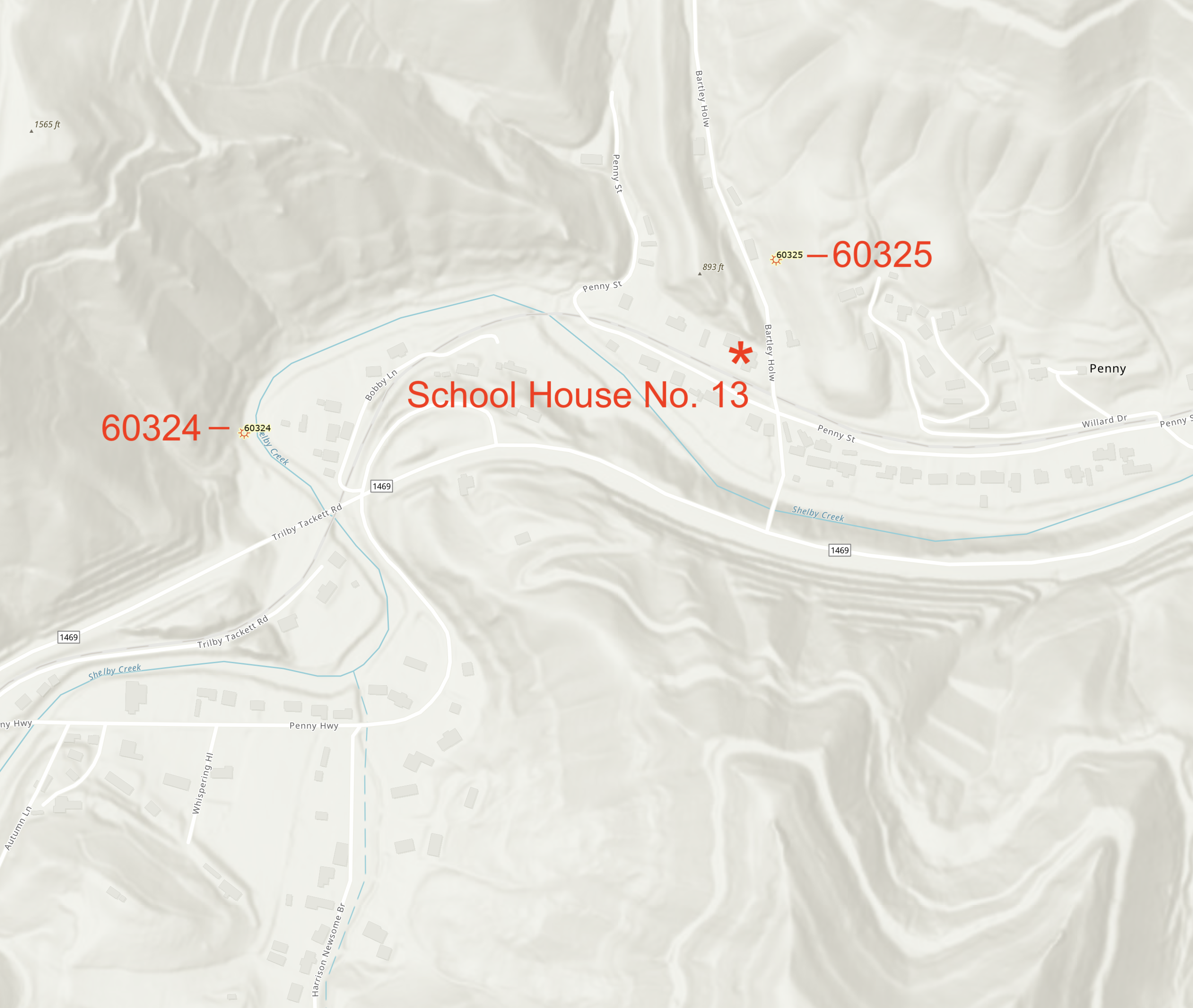
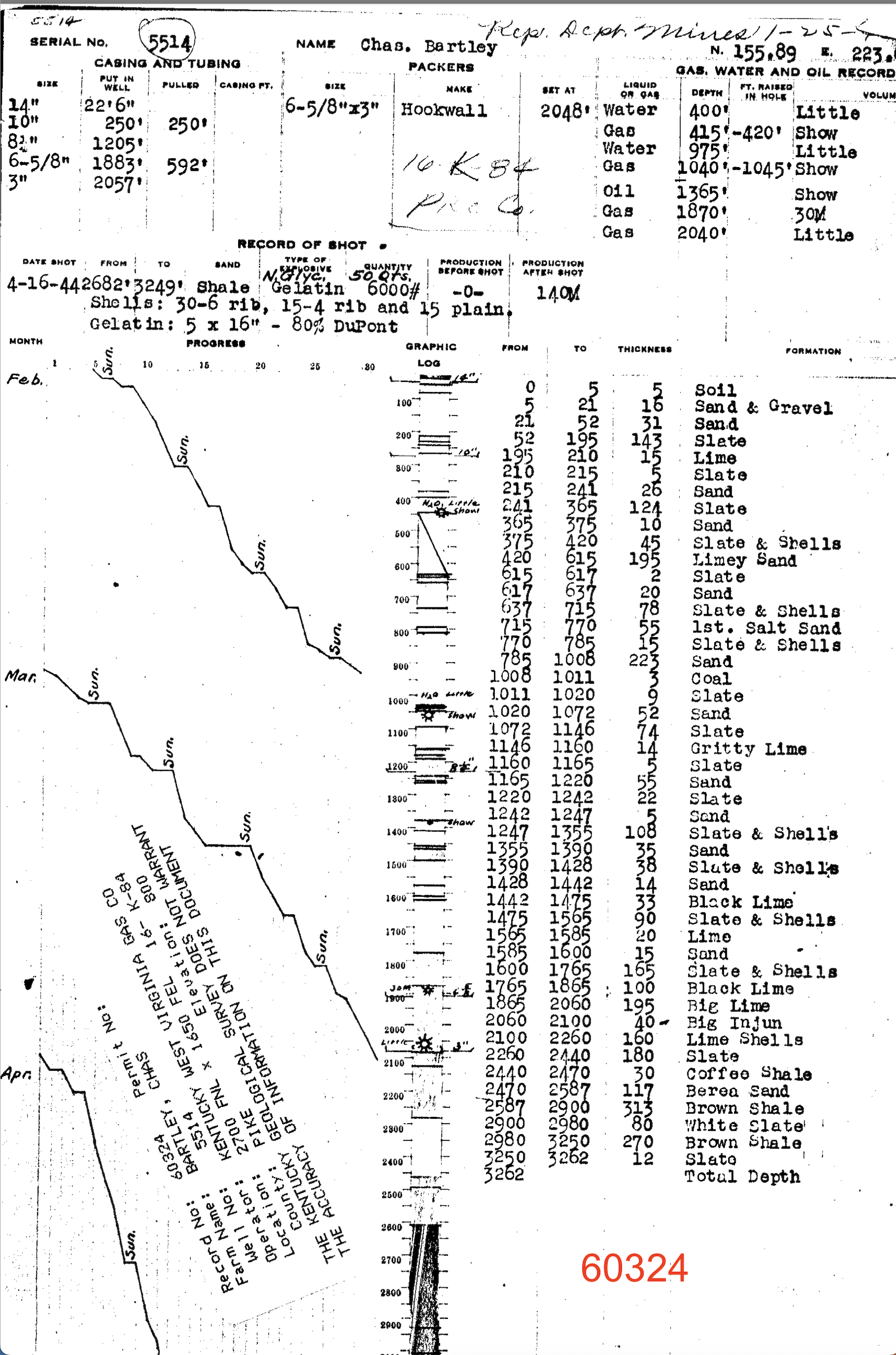
Gas Well Drillers Log 60324
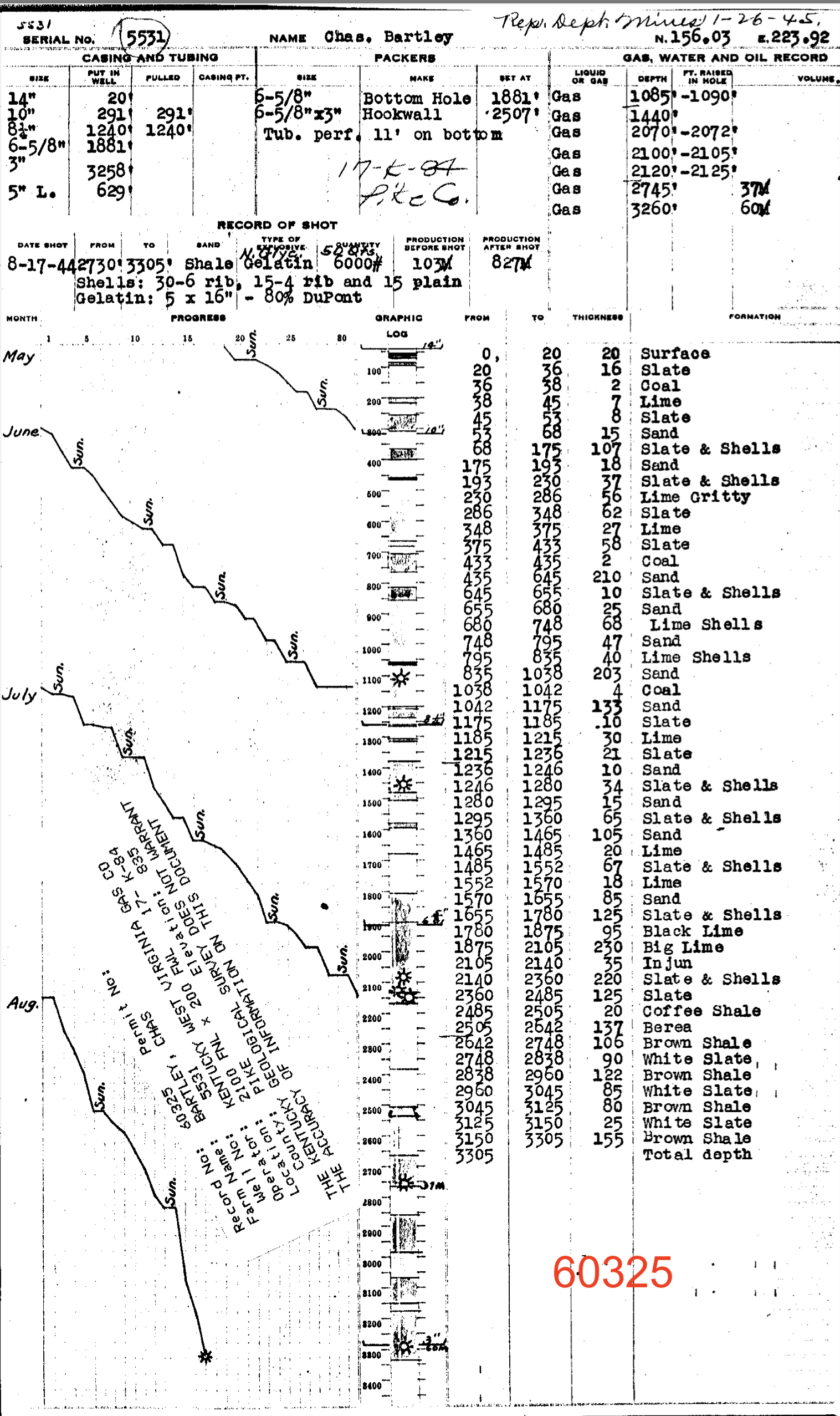
Gas Well Drillers Log 60325
Warfield Salt Works
During 1858 and 1859 David Dale Owens Kentucky Geological Survey Crew were surveying parts of Lawrence and Pike County. Owens noted the farms were quite small, lying in narrow valleys extending along streams; often embracing the sloping land at the foot of the hill, Owens’ valued flat land at $10 an acre and hill side at fifty cent to $1 an acre. Procuring and rafting saw logs is extensively carried on in many places. Wagon roads are almost unknown, yet the country could be traversed in many directions by roads which could be made at a small cost.
Salt making has been carried on for a short time at Warfield, on Tug river, from which point the salt is distributed either by pack horses through the country, or in canoes on the river.

Additional research on the Warfield Salt Works was done by a popular Civil War Historian, Marlitta H. Perkins was noted in post on East Kentucky Civil War Blog. One of the larger salt enterprises in Eastern Kentucky belonged to a Confederate general but, ironically, his salt works never contributed an ounce of salt to either army. Warfield was established in Lawrence County, now Martin, in the early 1850’s as a coal, salt and lumber community by George Rogers Clark Floyd and John Warfield of Virginia. It is located on the Tug Fork of the Big Sandy River, some sixty miles above Catlettsburg. On March 3, 1857, George Rogers Clark Floyd deeded all the Warfield property to his brother John B. Floyd. On May 23, 1861, Floyd was commissioned brigadier-general in the Confederate Army and subsequently had command of the “Virginia State Line,” which operated mainly in western and southwestern Virginia. Upon his departure, Floyd left agents in charge to look after the welfare of the property. Great quantities of salt were made at Warfield before the Civil War which were transported by boat to Catlettsburg but at the beginning of hostilities production ceased. On January 21, 1862, Floyd’s vast Warfield property of 15,000 acres came under a sheriff’s sale and was acquired by two Kentucky Union officers and their spouses, Colonel Laban T. Moore and wife Sarah, Col. George W. Gallup and wife Rebecca, as well as Joseph Tromstine, a Cincinnati investor and his wife Bertha. Thus the Warfield salt works remained in Union hands throughout the war and out of reach of the Confederacy. The production of salt was resumed after the end of the Civil War.
On July 2, 1867, the Warfield Coal and Salt Co. was deeded to Sallie B. Floyd, conveying all of Warfield, under general warranty to her.
[Lawrence Co. Deed Book I, pp. 245-247 ? /285-287]. On the same day, Robert W. Hughes was appointed her Executor and Trustee
[Lawrence Co. Deed Book I, p. 284-285