Table of Contents
Thomas Walker Bio
Thomas Walker, born January 25, 1715, was the third child and second son of Thomas Walker and Susan Peachy of King and Queen County Virginia. While Thomas Walker Jr. was still a young lad he lost his father and went to live with his sister, Mary Peachy, the second wife of Dr. George Gilmore. While living with his brother-in-law. Thomas came under the tutelage of George taking interest in being a physician, surgeon and druggist eventually enrolling into William and Mary College, although his name doesn’t appear on the college rolls; it was unlikely that he ever received a medical degree. On the representation, by his brother in law, Dr. George Gilmore, of his preparation and fitness, he was doubtless licensed to practice medicine by the county or other authorities, according to law. He settled in Fredericksburg and practiced medicine there in Eastern Virginia for a number of years. He won a more than local eminence as a physician and surgeon, and had a number of pupils among whom he may be mentioned George Gilmore, JR., his nephew, George Conway Taylor of Orange County, later an agent of the Loyal Company of Virginia.
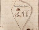
On some unknown date, during the year 1741, Thomas Walker was married to the widow of Nicholas Meriwether. Her maiden name was Mildred Thornton and she was the first cousin, once removed, to George Washington. By this marriage, Dr. Thomas Walker acquired possession of the Castle Hills estate comprising of about eleven thousand acres of land in present Albermarle County, which was originally part of a grant from King George II to one Nicholas Meriwether.
Thomas Walker continued practicing medicine, but with leading men of the day like George Washington, George Rodgers Clark, William Preston and John Floyd, for example his passion for exploring lie in the western territory of West Virginia. Walker finally turned surveyor in response to the need for taking care of and subdividing his large estate. Through his contact with speculative and adventurous spirts of the day, he learned of efforts made by the colony of Virginia to promote western colonization and the settlement of unappropriated lands. On 1743 the Virginia Council began to make large, and in some cases vast grants of land to individuals and corporations. Walker was adventurous in spirit, who found allurement in the fabled Western Virginia Territory. While Thomas was still young, he had gotten very close to William Winston, more senior than Walker, but a dear friend. Thomas Walker had made many tours with Willian Winston hunting and exploring, venturing in many headwaters the James River. Thomas Walker with the love of Exploration and Adventure, he had become one of the leaders of men in the Western Virginia Wilderness.
In 1748 Walker had accompanied as surveyor a party headed by Colonel James Patton, and consisting besides of Colonel John Buchanan, Patton’s son in law, Colonel James Woods and Major Charles Campbell, on a journey to Southwestern Virginia and Tennessee as far as the Indian and Clinch River. The object of this journey was to locate and survey extensive tracts of land, by the authority of a hundred thousand acre grant to Colonel James Patton by Virginia Council. One man that had led the original surveying party journey, was hunter and scout John Findlay. John Findlay was the same scout that had lead Daniel Boone to the salt springs on Middle Fork in the Fall of 1769. On this trip it was James Patton showed Thomas Walker his first look through Cumberland Gap.
By 1748 Thomas Walker, with his superior knowledge of the Western Virginia Territory, became an influential organizer of Loyal Company to take a first hand look at an 800,000 acre grant issued by Virginia Council. John Lewis was the primary signature and Thomas Walker was the second signature on grant. There were several names listed on the grant, but other names that stand out are Peter Jefferson (father of Thomas Jefferson) and Joshua Fry.
With a new quest set in place to explore this 800,000 acres of wilderness in the Western Virginia Territory, a name for new exploration company was chosen, Loyal Land Company of Virginia. John Lewis acted as the directive head of the company. In launching the company, he proceeded energetically, securing the appointment on December 12, 1749 and Thomas Walker was chosen as its agent for the purpose of exploring the Western Wilderness where the land was taken up.
[Credit: Dr. Thomas Walker and Loyal Company of Virginia by Archibald Henderson]
Journal
Having, on the 12 day of December last
been employed for a certain consideration
to go to the Westward in order to discover
a proper Place for a Settlement I left
my House on the Sixth day of March at 10
o’clock, 1749-50, in Company with Ambrose
Powell, William Tomlinson, Colby Chew, Henry
Lawless, & John Hughs. Each man had a
Horse and we had two to carry the Baggage.
I lodged this night at Colo. Joshua Fry’s
in Albemarle, which County includes the chief
of the head Branches of James River on the
east side of the blue Ridge.
March 1750
[March] 7th [1750]
7 March 1750 Wee set off about 8 but the day proving wet
we only went to Thomas Joplin’s on Rockfish.
This is a pretty River, which might at a small
expense be made fit for transporting Tobacco;
but it has lately been stopped by a Mill Dam
near the Mouth to the prejudice of the upper
Inhabitants, who would at their own expence clear
and make it navigable, were they permitted.
[March] 8th [1750]
8th. We left Joplin’s early. It began to rain about
Noon, I left my People at Thomas Jones’s and
went to the Reverend Mr. Robert Rose’s on
Tye River. This is about the size of Rockfish, as
yet open, but how long the Avarice of Millers
will permit it to be so, I know not. At present
the Inhabitants enjoy plenty of fine fish, as Shads
in their season, Carp, Rocks, Fat-Backs which I
suppose to be Tench, Perch Mullets, etc.
[March] 9th [1750]
9th. As the weather continues unlikely, I moved only
to Baylor Walker’s Quarters.
[March] 10th [1750]
10th. The weather is still Cloudy, and leaving my
People at the Quarter, I rode to Mr. John Harvie’s
where I dined and return’d to the illegible in ye Evening.
[March] 11th [1750]
11th. The Sabbath.
[March] 12th [1750]
12th. We crossed the Fluvanna & lodged at Thomas
Hunt’s.
[March] 13th [1750]
13th. We went early to William Calloway’s and sup-
plied ourselves with Rum, Thread, and other necessaries &
from thence took the main Waggon Road leading
to Wood’s or the New River. It is not well clear’d
or beaten yet, but will be a very good one with
proper management. This night we lodged in
Adam Beard’s low grounds. Beard is an ignorant,
impudent, brutish fellow, and would have taken us up,
had it not been for a reason, easily to be suggested.
[March] 14th [1750]
14th. We went from Beards to Nicholas Welches, where
we bought corn for our Horses, and had some Victuals
dress’d for Breakfast. After wards we crossed the
Blue Ridge. The Ascent and Descent is so easie, that
a Stranger would not know, when he crossed the
Ridge. It began to rain about Noon and continued
till night. we lodged at William Armstrongs. corn
is very scarce in these Parts
[March] 15th [1750]
15th. Wee went to the great Lick on A Branch of the Staunton and bought Corn of Michael Campbell
for our Horses. This Lick has been one of the best
places for Game in these parts and would have
been of much greater advantage to the Inhabitants
than it has been, if the Hunters had not Killed
the Buffaloes for diversion, and the Elks and Deer
for their Skins. This afternoon we got to the Staunton
where the Houses of the Inhabitans [sic.] had been
carryed off with their grain, and Fences by
the Fresh Last Summer, and lodged at James
Robinson’s, the only place I could hear of, where
they had Corn to Spare, notwithstanding the
the [sic.] land is such that an industrious man might
make 100 Barrels a share in a seasonable year.
March 16th [1750]
16th March 1750. We kept up the Staunton to William Englishes.
He lives on a small Branch, and was not much
hurt by the Fresh. He has a mill, which is the
furthest back except one lately built by the Sect of People,
who call themselves of the Brotherhood
of Euphrates, and are commonly called the Duncards
[March] 17th [1750]
17th who are the upper Inhabitants of the New River, which
is about 400 yards wide at this Place. They live on
the west side, and we were obliged to swim our
Horses over. The Duncards are an odd set of people,
who make it a matter of Religion not to shave
their Beards, ly on Beds, or eat Flesh, though at
present in the last, they transgress, being constrained
to it, as they say, by the want of a sufficiency of
Grain and Roots, they having not long been seated
here. I doubt the plenty and deliciousness of the Venison
& Turkeys has contributed not a little to this. The
unmarried have no private Property, but live on
a common Stock. They dont baptize either Young
or Old, they keep their Sabbath on Saturday, & hold
that all men shall be happy hereafter, but first
must pass through punishment according to their
Sins. They are very hospitable.
[March] 18th [1750]
18th. The Sabbath.
[March] 19th [1750]
19th. We could not find our Horses and Spent the day
in Looking for them. In the evening we found
their track
[March] 20th [1750]
20th. We went very early to the track of our Horses
& after following them six or seven miles we
found them all together. we returnd to the Duncards
about 10 o’clock, and having purchased half a Busshell
of meal and as much small Homony we set off and
Lodged on a small Run between Peak Creek and
Reedy Creek.
[March] 21st [1750]
21st. We got to Reedy Creek and Camped near James
McCall’s. I went to his house and Lodged and bought
what Bacon I wanted
[March] 22d [1750]
22d. I return’d to my People early. we got to a
large Spring about five miles below Davis’es Bottom
on Holstons River and Camped.
[March] 23d [1750]
23d. We kept down Holston’s River about four miles
and Camped; and then Mr. Powel and I went
to look for Samuel Stalnaker, who I had been
inform’d was just moved out to Settle. We found
his Camp, and return’d to our own in the
Evening.
[March] 24 [1750]
24. We went to Stalnakers, helped him to raise
his house and Camped about a Quarter of a
Mile below him. In April 1748, I met the
above mentioned Stalnaker between the Reedy
Creek Settlement, and Holstons River, on his way
to the Cherokee Indians, and expected him to
pilate me as far as he knew but his affairs
would not permit him to go with me.
[March] 25th [1750]
25th. The Sabbath. Grass is plenty in the low
Grounds.
[March] 26th [1750]
26th. We left the Inhabitans, and kept [nigh]
West to a large Spring on a Branch of the
North fork of Holston. Thunder, Lightning, and
rain before day.
[March] 27th [1750]
27th. It began to snow in the morning and continued
till Noon. The Land is very hilly from West to
North. Some Snow lies on the tops of the mountains
N: W: from us.
[March] 28th [1750]
28th. We travelled to the lower end of
Giants Ditch on Reedy Creek.
[March] 29th [1750]
29th. Our Dogs
were very uneasie most of this Night.
[March] 30th [1750]
30th. We kept down Reedy Creek, and discover’d
the tracks of about 20 Indians, that had gone up
the Creek between the time we Camped
last Night, & set of[f] this Morning. We suppose
they made our Dogs so restless last Night. We
Camped on Reedy Creek.
30th. We caught two young Buffaloes, one of which
we killed, & having cut and marked the other we
turn’d him out.
[March] 31st [1750]
31st. We kept down Reedy Creek to Holston where
we measured an Elm 25 feet round 3 feet from
the Ground. we saw young Sheldrakes, we went
down the River to the north Fork and up the
north Fork about a quarter of a mile to a Fords,
and then crossed it. In the Fork between Holstons
and the North River are five Indian Houses built
with loggs and cover’d with Bark, and there were
abundance of Bones, some whole Pots and Pans,
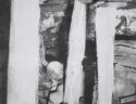
some broken, and many pieces of of [sic.] mats & Cloth.
on the west Side of the North River is four Indian
Houses such as before mentioned.
we went four miles Below the North River
and Camped on the Bank of Holstons; opposite to
a large Indian Fort.
April 1750
April ye 1st
April ye 1st. The Sabbath. we saw Perch, Mullets,
and Carp in plenty, and caught one of the
large Sort of Cat Fish. I marked my Name, the
day of the month, and date of the year on Several
Beech Trees.
2d
2d. we left Holston & travelled through small
Hills till about Noon, when one of our Horses
being choaked by eating Reeds too gredily we stopped
having tavelled [sic.] 7 miles.
3d
3d. Our horse being recover’d we travelled to the
Rocky Ridge. I went up to the top, to Look for
a Pass but found it so Rocky that I concluded not
to Attempt it there. This Ridge may be kn
own by
Sight, at a distance. To the Eastward are many small
Mountains, and a Buffaloe Road between them and
the Ridge. The growth is Pine on the top and
the Rocks look white at a distance. we went
Seven miles this day.
[April] 4th [1750]
4th. We kept under the Rocky Ridge crossing
several small Branches to the head of Holly
Creek. we saw many small Licks and plenty of
Deer.
[April] 5th [1750]
5th. we went down Holly Creek. There is much
Holly in the Low Grounds & some Laurel, and Ivy.
About 3 in the afternoon the Ridge appeared less
Stony, and we passed it, and camped on a Small
Branch about a mile from the top. My Riding
Horse choaked himself this Evening and I drenched
him with Water to wash down the Reeds, and it answered
the End
[April] 6th [1750]
6th. It proveing wet we did not move.
[April] 7th [1750]
7th. We rode 8 miles over broken Land. It Snowed most
of the day. In the Evening our dogs caught a large
He Bear, which before we could come up to shoot
him, had wounded a Dog of mine, so that he could not
Travel, and we carried him on Horseback, till he
recovered.
[April] 8th [1750]
8th. The Sabbath. Still Snow.
[April] 9th [1750]
9th. We travelled to a river, which I suppose to
be that which the Hunters Call Clinches River
from one Clinch a Hunter, who first found it.
we marked Several Beeches on the East side.
we could not find a ford Shallow eneugh to carry
our Baggage over on our horses. Ambrose Powell
Forded over on one horse, and we drove the
others after him. We then made a Raft and
carried over one Load of Baggage, but when the
Raft was brought back, it was so heavy that it
would not carry anything more dry.
[April] 10th [1750]
10th. We waded and carryed the remainder of our
Baggage on our Shoulders at two turns over the
River, which is about one hundred and thirty
yards wide, we went on about five miles and
Camped on a small Branch.
[April] 11th [1750]
11th. Having travelled 5 miles to and over an High
Mountain, we came to Turkey Creek which we kept
down 4 Miles, It lies between two Ridges of Mountains
that to the Eastward being the highest
12th. We kept down the Creek 2 miles further where it
meets with a large Branch coming from the South
West, and thence runs through the East Ridge making
a very good Pass; and a large Buffaloe road goes
from the Fork to the Creek over the west Ridge, which
we took and found the Ascent and Descent tollerably
easie. From this Mountain we rode four miles to Bear-
grass River. Small Ceder Trees are very plenty on the
flat ground nigh the River and some Barberry Trees
on the East side of the River. on the Banks is some
Bear-grass. we kept up the River two miles &
I found some Small pieces of Coal, and a great
plenty of very good yellow Flint. The Water is the
most transparent I Ever saw. it is about 70 yds. Wide.
April 13th [1750]
April 13th. We went four miles to large Creek, which we
called Cedar Creek, being a Branch of Bear-grass, and
from thence Six miles to Cave gap the land being
Levil. On the North side of the Gap, is a large
Spring, which falls very fast, and just above the
Spring is a small Entrance, to a large Cave,
Which the Spring runs through, and there is a
constant Stream of Cool air issuing out. The
Spring is Suffitient to turn a mill. just at the
foot of the Hill is a Laurel Thicket, and the
Spring Water runs through it. On the South side
is a plain Indian Road. on the top of the Ridge
are several Trees Marked with Crosses, others Blazed
and several Figures painted on them. As I went
down on the other Side, I soon came to some Laurel
in the head of a Branch. A Beech Stands on the
left hand, on which I cut my name. This Gap
may be seen at a considerable distance; and
there is no other, that I Know of, except one about
two miles to the North of it, which does not appear
to be so low as the other. The Mountain on the North
Side of the Gap is very steep and Rocky. but on the
South side it is not so. We called it Steep Ridge.
At the foot of the hill on the North West side
we came to a Branch, that made a great deal of
flat Land. We kept down it 2 miles. Several other
Branches Coming in to make it a large Creek, and
we called it Flat Creek. We camped on the Bank
where we found Very good Coal. I did not se any
Lime Stone beyond this Ridge. we rode 13 miles
this day
[April] 14th [1750]
14th. We kept down the Creek 5 miles Chiefly along
the Indian Road
[April] 15 [1750]
15th. Easter Sunday. Being in bad grounds for our
Horses we moved 7 miles along the Indian Road, to
Clover Creek. Clover and Hop Vines are plenty here
April 16th [1750]
April 16th. Rain. I made a Pair of Indian Shoes, those I
brought out being bad
[April] 17th [1750]
17th. Still Rain. I went down the Creek a hunting and:
found that it runs into a River about a mile below
our Camp. This, which is Flat Creek and some others
join’d, I Called Cumberland River
[April] 18th [1750]
18th. Still Cloudy. We kept down the Creek to the River, and down the River along, the Indian Road to
where it Crossed. Indians have lived about this Ford
some years ago. we kept on down the South side.
after Riding 5 miles from our Camp We left the
River: it being very crooked. In Rideing 3 miles we
came on it again. it is about 60 or 70 yards wide.
we Rode 8 miles this day
[April] 19 [1750]
19th. Wee left the River but in four miles we came
on it again at the Mouth of Licking Creek, which
we went up and down another. In the Fork of Licking
Creek is a Lick much used By Buffaloes and many
large Roads lead to it. This afternoon Ambrose Powell
was bit by a Bear in his Knee. we rode 7 miles this
day–
[April] 20 [1750]
20th. We kept down the Creek 2 miles to the River again.
It appears not any wider here than at the mouth
of Clover Creek, but much deeper. I thought it
proper to Cross the River and began a bark Conoe.
[April] 21st [1750]
21st. We finished the Conoe and tryed her. About noon
it began to thunder lighten hail and rain prodigiously
and continued about 2 hours.–
[April] 22d [1750]
22d. The Sabbath. One of horses was found unable to walk
this morning. I then Propose’d that with 2 of the
Company I would proceed, and the other three Should
Continue here till our return, which was agreed to,
and Lots were drawn to determine who should go
they all being desirous of it. Ambrose Powell, and Colby
Chew were the fortunate Persons
[April] 23d [1750]
23d. Haveing carried our baggage over in the Bark
Conoe, and Swam our Horses, we all Crossed the River.
Then Ambrose Powell, Colby Chew, and I departed Leaving
the others to provide and salt some Bear, build an house
and plant some Peach Stones and Corn. We travelled
about 12 miles and encamped on Crooked Creek.
The mountains are very sma11 hereabouts and here
is a great deal of flat Land. We got through the
Coal to day.
[April] 24th [1750]
24th. We kept on Westerly 18 miles, got Clear of the
mountains and found the Land poor and the woods very
Thick beyond them and Laurel and Ivy in & near the
Branches. Our Horses suffered very much here for
want of food. This day we Came on the fresh Track
of 7 or 8 Indians, but could not overtake them.
[April] 25 [1750]
25th. We kept on West 5 miles, the Land continuing
much Same, the Laurel rather growing worse, and
the food scarcer. I got up a Tree on a Ridge and saw
the Growth of the Land much the same as Far as
my Sight could reach. I then concluded to return to the
rest of my company. I kept on my track 1 mile
then Turn’d Southerly & went to Cumberland River at the
mouth of a water Course, that I named Rocky
Creek.
[April] 26th [1750]
26th. The River is 150 yards wide and appears to be
navigable from this place almost to the mouth of
Clover Creek. Rocky Creek runs within 40 yards of the
River Bank then turns off, and runs up the River
Surrounding about 25 Acres of Land before it falls
into the River. The Banks of the River and Creek are
a sufficient Fence almost all the way. On the
Lower side of the mouth of the Creek is an Ash mark’d
T W a Red Oak A P a white Hiccory C. C. besides several
Trees blazed Several ways with 3 Chops over Each blaze.
we went up the North Side of the River 8 miles, and
Camped on a Small Branch. A Bear Broke one of my Dogs
forelegs
[April] 27 [1750]
27th. We crossed Indian Creek and Went down Meadow
Creek to the River. There Comes in another from the
Southward as big as this we are on Below the mouth
of this Creek, and above the mouth are the remains of
several Indian Cabbins and amongst them a round
Hill made by Art about 20 feet high and 60 over the
Top. we went up the River, and Camped on the Bank.
[April] 28th [1750]
28th. We kept up the River to our Company whom
we found all well, but the lame Horse was as bad as
we left him, and another had been bit in the Nose
by a Snake. I rub’d the wounds with Bears oil, and
gave him a drench of the same and another of the
decoction of Rattle Snake root some time after. The
People I left had built an House 12 by 8, clear’d and
broke up some ground, & planted Corn, and Peach
Stones. They also had Killed several Bears and cured the
Meat. This day Colby Chew and his Horse fell down the
Bank. I Bled and gave him Volatile drops, & he soon recover’d.
[April] 29th [1750]
29th. The Sabbath. The bitten Horse is better. 3 Quarters
of A mile below the House is a Pond in the low Ground
of the River a Quarter of a mile in Length and 200 yds
wide much frequented by Fowl.
[April] 30th [1750]
30th. I blaz’d a way from our House to the River.
On the other side of the River is a large Elm cut
down and barked about 20 feet and another Standing
just by it with the Bark cut around at the root and
about 15 feet above. About 200 yards below there is
a white Hiccory Barked about 15 feet. The depth
of water here, when the lowest that I have seen it,
is about 7 or 8 feet, the Bottom of the River Sandy, ye
Banks very high, & the Current very Slow. The bitten
Horse being much mended we set off and left the lame one.
He is white, branded on the near Buttock with a swivil
Stirrups Iron, and is old. We left the River and having crossed
Several Hills and Branches Camped in a Valley North
from the House.
May, 1750
May ye 1st, 1750
May the 1st 1750. Another Horse being bit I applyed
Bears Oil as before mention’d. we got to Powells River
in the afternoon and went down it along an Indian
Road much frequented, to the mouth of a Creek
on the West side of the River, where we camped. The
Indian Road goes up the Creek, and I think it is that
which goes through Cave Gap.
[May] 2d [1750]
2d. We kept down the River. At the mouth of a Creek
that comes in on the East side is a Lick, and I
believe there was a hundred Buffaloes at it. About
2 oClock we had a Shower of rain. we camped on the
River, which is very crooked.
[May] 3d [1750]
3d. We crossed a narrow Neck of Land, came on the
River again and kept down it to an Indian Camp,
that had been built this Spring, and in it we took
up our Quarters. It began to rain about Noon and
continued till Night.
[May] 4th [1750]
4th. We crossed a narrow Neck of Land and came on the
River again, which we kept down till it turn’d to the
Westward, we then left it, and went up a Creek, which
we Called Colby’s Creek. The River is about 50 yards
over where we left it.
[May] 5th [1750]
5th. We got to Tomlinsons River, which is about the size
of Powells River, and I cut my name on a Beech,
that Stands on the North Side of the River. Here is
plenty of Coal in the South Bank opposite to our Camp.
[May] 6th [1750]
6th. The Sabbath. I saw Goslings, which shows that wild
Geese stay here all the year. Ambrose Powell had
the misfortune to sprain his well knee.
[May] 7th [1750]
7th. We went down Tomlinsons River the Land being very
broken and our way embarrassed by Trees, that had
been blown down about 2 years ago.
[May] 8th [1750]
8th. We went up a Creek on the North Side of the River.
[May] 9th [1750]
9th. We got to Lawlesses River which is much like the
others. The Mountains here are very Steep and on Some
of them there is Laurel and Ivy. The tops of the
Mountains are very Rocky and some part of the Rocks
seem to be composed of Shells, Nuts and many other
Substances petrified and cemented together With a kind
of Flint. Wee left the River and after travelling some
Miles we got among Trees that had been Blown down
about 2 years, and Were obliged to go down a Creek
to the River again, the Small Branches and mountains
being impassable.
[May] 10th [1750]
l0th. We Staid on the River, and dressed an Elk’s skin
to make Indian Shoes, most of ours being quite
worn out.
[May] 11th [1750]
11th. We left the River, found the mountains very bad,
and got to a Rock by the the side of a Creek
Sufficient to Shelter 200 men from Rain. Finding
it so convenient we concluded to stay and put our Elk’s
skins in order for shoes and make them.
[May] 12th [1750]
12th. Under the Rock is a Soft kind of Stone almost like
Allum in tast below it A Layer of Coal about 12 Inches
think and white Clay under that. I called the Run
Allum Creek. I have observed Several mornings past,
that the Trees begin to drop just before day & continue
dripping till almost sun rise, as if it rain’d slowly.
we had some rain this day.
[May] 13th [1750]
13th. The Sabbath.
[May] 14th [1750]
14th. When our Elk’s Skin was prepared we had lost
every Awl that we brought out, and I made one
with the shank of an old Fishing hook, the other Peo-
ple made two of horse Shoe Nailes, and with these
we made our Shoes or Moccosons,
14 We wrote several of our Names with Coal under
the Rock, & I wrote our names the time of our
comeing and leaving this place on paper and stuck it
to the Rock with Morter, and then set off. We crossed
Hughes’s River and Lay on a large Branch of it.
There was no dew this morning but a shower of Rain
about 6 oClock. The River is about 50 yards wide.
[May] 15th [1750]
15th. Laurel and Ivy encrease upon us as we go up the
Branch. About noon it began to rain & we took up
our Quarters in a Valley between very Steep Hills.
[May] 16 [1750]
16. We crossed Several Ridges and Branches. About two
in the afternoon I was taken with a Violent Pain in my Hip.
[May] 17th [1750]
17th. Laurel and Ivy are very plenty and the Hills still
very steep. The Woods have been Burnt some years
past, and are now very thick, the Timber being almost
all kill’d. We camped on a Branch of Naked Creek.
The Pain in my Hip is something asswaged.
[May] 18th [1750]
18th. We went up Naked Creek to the head and had a
plain Buffaloe Road most of the way. From thence
we proceeded down Wolf Creek and on it we encamped.
[May] 19 [1750]
19. We kept down ye Creek to Hunting Creek, which we
Crossed & left. It rained Most of the afternoon.
[May] 20th [1750]
20th. The Sabbath. It began to rain about Noon and
continued till next day.
[May] 21 [1750]
21st. It left off raining about 8. we crossed several
Ridges and small Branches & camped on a Branch of
Hunting Creek. in the Evening it rained very hard.
[May] 22d [1750]
22d. We went down the Branch to Hunting Creek & kept
it to Milley’s River.
[May] 23rd [1750]
23rd. Wee attempted to go down the River but could not.
We then Crossed Hunting Creek and attempted to go up
the River but could not. it being Very deep We
began a Bark Conoe. The River is about 90 or 100 yds
wide. I Blazed Several Trees in the Fork and marked
T W on a Sycomore Tree 40 feet round. It has a
large Hole on the N: W: side about 20 feet from
the Ground and is divided into 3 Branches just
by the hole, and it stands about 80 yards above
the Mouth of Hunting Creek.
[May] 24th [1750]
24th. We finished the Conoe and crossed the River about
noon, and I marked a Sycomore 30 feet round and several
Beeches on the North side of the River opposite to the mouth
of the Creek. Game is Very Scarce hereabouts.
[May] 25th [1750]
25th. It began to rain before day and continued till
about noon. We travelled about 4 miles on a Ridge,
and camped on a small Branch.
[May] 26th [1750]
26th. We kept down the Branch almost to the River,
and up a Creek, and then along a Ridge till our Dogs
roused a large Buck Elk, which We followed Down
to a Creek. He kill’d Ambrose Powell’s Dog in the
Chase, and we named the Run Tumbler’s Creek, the
Dog being of that Name.
[May] 27 [1750]
27th. The Sabbath.
[May] 28th [1750]
28th. Cloudy. We could not get our Horses till almost
Night, when we went down the Branch. We lay on
to the main Creek, and turn’d up it.
[May] 29 [1750]
29th. Wee proceeded up the Creek 7 miles, and then
took a North Branch & went up it 5 Miles and
then we encamped on it.
[May] 30th [1750]
30th. We went to the head of the Branch we Lay
on 12 miles. A shower of Rain fell this day.
The Woods are burnt fresh about here and are
the only fresh burnt Woods we have seen these
Six Weeks.
[May] 31st [1750]
31st. We crossed 2 Mountains and camped just by
a Wolfs Den. They were very impudent and after
they had been twice shot at, they kept howling
about the Camp. It rained till Noon this day.
June 1750
June ye 1st [1750]
June ye 1st. We found the Wolfs Den and caught 4 of
the young ones. It rained this morning. we Went
up a Creek crossed a mountain and went through
a Gap, and then, camped on the head of A Branch.
[June] 2d [1750]
2d. We went down the Branch to A River 70 yards
wide, which I Called Fredericks River. we kept
up it half a mile to a Ford, where we crossed and
proceeded up on the North Side 3 miles. It rained most
of the afternoon. Elks are Very Plenty on this River.
[June] 3rd [1750]
3rd. Whit-Sunday. It Rained most of the day.
[June] 4th [1750]
4th. I blazed Several Trees four ways on the out side
of the low Grounds by a Buffaloe Road, and mark’ed
My Name on Several Beech Trees. Also I marked
Some by the River side just below a mossing place with
an Island in it. We left the River about 10 oClock & got
to Falling Creek, and went up it till 5 in the
Afternoon when a very black Cloud appearing we turn’d
out our Horses got tent Poles up, and were just stretching
a Tent, when it began to rain and hail, and was succeeded
by a violent Wind, which Blew down our Tent & a great
Many Trees about it, Several large ones within 30 yds
of the Tent, we all Left the place in confusion and ran
different ways for shelter. After the Storm was over
we met at the Tent, and found all safe.
[June] 5th [1750]
5th. There was a violent Shower of Rain before day. This
morning we went up the Creek about 3 miles, and
were thus obliged to leave it, the Timber being so
blown down, that we could not get through.
After we left the Creek we kept on a Ridge 4 miles
then turn’d down to the head of A Branch, and it
began to rain and continued raining very hard till
Night.
[June] 6th [1750]
6th. We went down the Branch till it became a large
Creek. It runs very Swift, falling more than any
of the Branches we have been on of late. I called it
Rapid Creek. After we had gone 8 miles we could
not ford, and we Camped in the low Ground. There
is great Sign of Indians on this Creek.
[June] 7th [1750]
7th. The Creek being fordable we Crossed it & kept down
12 miles to a River about 100 yards over, Which We
called Louisa River. The Creek is about 30 yards wide, &
part of ye River breaks into ye Creek making an Island
on which We Camped.
[June] 8th [1750]
8th. The River is so deep we Cannot ford it and as it
is falling we conclude to stay & hunt. In the after
-noon Mr. Powell and my Self was a hunting about
a mile & half from the Camp, and heard a gun just
below us on the other side of the River, and as none
of our People could cross I was in hopes of geting
some direction from the Person, but could not
find him.
[June] 9th [1750]
9th. We crossed the River & went down it to the mouth
of of a Creek & up the Creek to the head and over a
Ridge into a steep Valley and Camped.
[June] 10th [1750]
10th. Trinity Sunday. Being in very bad Ground for our
Horses we concluded to move. we were very much
hindered by the Trees, that were blown down on
Monday last. we camped on a small Branch.
[June] 11th [1750]
11th. It rain’d violently the Latter part of the night
& till 9 oClock. The Branch is impassable at present.
We lost a Tomohawk & a cann by the Flood.
[June] 12th [1750]
12th. The Water being low we went down the Branch
to a large Creek, & up the Creek. Many of the Trees
in the Branches are Wash’d up by the Roots and
others barked by the old trees, that went down ye
Stream. The Roots in the Bottom of the Runs are
Barked by the Stones.
[June] 13th [1750]
13th. We are much hindered by the Gust. & a shower of
Rain about Noon. Game is Very scarce here, and
the mountains very bad the tops of the Ridges
being so covered with Ivy and the sides so steep
and stony, that we were obliged to cut our way
through with our Tomohawks.
[June] 14th [1750]
14th. The Woods are still bad & Game scarce. It rain’d
to day about Noon & we Camped on the top of A
Ridge.
[June] 15th [1750]
15th. We got on a large Creek where Turkey are plen
-ty and some Elks. we went a hunting & killed 3 Turkeys.
[June] 16th [1750]
16th. Hunted & killed 3 Bears & some Turkeys.
[June] 17th [1750]
17th. The Sabbath. We kill’d a large Buck Elk.
[June] 18th [1750]
18th. having prepared a good stock of meat, we left
the Creek crossing several Branches and Ridges.
the Woods still continuing bad the Weather hot &
our Horses so far Spent, that we are all obliged
to walk.
[June] 19th [1750]
June 19th. We got to Laurel Creek early this morning,
and met so impudent A Bull Buffaloe that we
were obliged to shoot him, or he would have been amongst
us. we then went up the Creek six miles, thence up
a North Branch of it to the Head, and attempted
to Cross a mountain, but it proved so high and
difficult, that we were oblig’d to Camp on the side
of it. This Ridge is nigh the eastern edge of the
Coal Land.
[June] 20th [1750]
20th. We got to the top of the Mountain and Could
discover a flat to the South & South East. we
went down from the Ridge to a Branch and down
the Branch to Laurel Creek not far from where we
left it yesterday, & camped. my rideing Horse was bit by
a Snake this day, and having no Bears Oil I rub’d the
wounds with a piece of fat meat, which had the
desired effect.
[June] 21st [1750]
21st. We found the Level Nigh the Creek so full of Laurel
that we were obliged to go up a Small Branch, and from
the head of that to the Creek again, and found it good
travelling a Small distance from the Creek. we Camped
on the Creek. Deer are Very scarce on the Coal Land,
I having seen but 4, since the 30th of April.
[June] 22nd [1750]
22nd. We kept up to the head of the Creek the Land being
Leveller than we have lately seen, and here are some
large Savanna’s. many of the Branches are full of Laurel
and Ivy. Deer and Bears are plenty.
[June] 23rd [1750]
23rd. Land continues level with Laurel and Ivy & we got to
a large Creek with very high & steep Banks full of Rocks,
which I call’d Clifty Creek, the Rocks are 100 feet perpendiculer
in some Places.
[June] 24th [1750]
24th. The Sabbath.
[June] 25th [1750]
25th. We Crossed Clifty Creek. Here is a little Coal and
the Land still flat.
[June] 26th [1750]
26th. We crossed a Creek, that we called Dismal Creek
the Banks being the worst and the Laurel the thickest
I have seen. The Land is Mountainous on the East
Side of the Dismal Creek, and the Laurels end in a
few miles. We camped on a Small Branch.
[June] 27th [1750]
27th. The Land is very high & we Crossed several
Ridges and camped on a small Branch. it rained
about Noon and continued till the next day.
[June] 28th [1750]
28th. It continued raining till Noon, and we set off as soon
as it ceased and went down the Branch we lay on
to the New River, just below the Mouth of Green Bryer.
Powell, Tomlinson and my self striped, and went into
the New River to try, if we could wade over at
any place. After some time having found a place
we return’d to the others and took such things as
would take damage by Water on our Shoulders, and waded
over Leading our Horses. The Bottom is very uneven, the
Rocks very slippery and the Current very Strong most
of the way. The River is nigh 500 yards over. We Camped
in the low Ground opposite to the mouth of Green
Bryer.
[June] 29th [1750]
29th. We kept up Green Bryer. It being a wet day we
went only 2 Miles. and Camped on the North side.
[June] 30th [1750]
30th. We went 7 miles up the River, which is very crooked.
July 1750
July ye 1st [1750]
July ye 1st. The Sabbath. Our salt being almost spent We
travelled 10 miles sometimes on the River, and at other
times some distance from it.
[July] 2d [1750]
2d. We kept up the River the chief part of this day and
we travelled about 10 miles.
[July] 3d [1750]
3d. We went Up the River 10 miles to day.
[July] 5th [1750]
4th. We went up the River 10 miles through very bad
woods.
[July] 5th [1750]
5th. The way growing worse, we travelled 9 miles only.
[July] 6th [1750]
6th. We left the River. The low grounds on it are of
very little Value. but on the Branches are very good,
and there is a great deal of it, and the high land is
very good in many places. We got on a large Creek
called Anthony’s Creek, which affords a great deal of Very
good Land, and it is chiefly-bought. we kept up the
Creek 4 miles & Camped. This Creek took it Name from
an Indian, Called John Anthony, that frequently hunts
in these Woods. There are some inhabitants on the Bran-
ches of Green Bryer, but we missed their Plantations.
[July] 7th [1750]
7th. We kept up the Creek, and about Noon 5 men
overtok us & inform’d us we were only 8 miles
from the inhabitants on a Branch of James River called
Jackson’s River. We exchanged some Tallow for meal &
parted. We Camped on a Creek nigh the top of the Allega
-ny Ridge Which We named Ragged Creek.
[July] 8th [1750]
8th. Having Shaved, Shifted, & made new shoes we left our
Useless Raggs at ye Camp & got to Walker Johnston’s about Noon.
We Moved over to Robert Armstrong’s in the After-
noon & staid there all Night. The People here are very
hospitable and would be better able to support Travellers
was it not for the great number of Indian Warriers
that frequently take what they want from them, much
to Their prejudice.
[July] 9th [1750]
9th. We went to the hot Springs & found Six Invalides
there. The Spring Water is very Clear & warmer than
new Milk, and there is a spring of cold water within
20 feet of the Warm one. I left one of my Company
this day.
[July] 10th [1750]
l0th. Having a Path We rode 20 miles & lodged at Captain
Jemyson’s below the Panther Gap. Two of my Company
went to a Smith to get their Horses Shod.
[July] 11th [1750]
11th. Our Way mending We travelled 30 miles to Augusta
Court House, where I found Mr. Andrew Johnston, the
first of my acquaintance I had seen, since the 26 day
of March.
[July] 12th [1750]
12th. Mr. Johnston lent me a fresh Hose and sent my
Horses to Mr. David Stewards who was so kind as to
give them Pastureage. About 8 oClock I set off leaving
all my Company. It began to rain about 2 in the After-
noon & I lodged at Captain David Lewis’s about
34 miles from Augusta Court House.
[July] 13th [1750]
13th. I got Home about Noon.
We kill’d in the Journey 13 Buffaloes, 8 Elks, 53
Bears, 20 Deer, 4 Wild Geese, about 150 Turkeys, beside
Small Game. We might have kill’d three times as much
meat, if we had wanted it.
[Credit: University of Virginia]
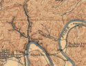
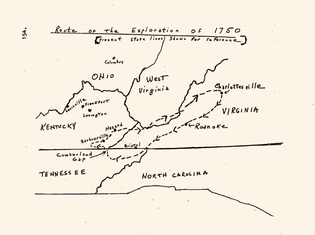
Thomas Walkers Projected Path Map #1

[Credit: Social Studies for Kids/ Thomas Walker Explorer]
Map #2
[The Virginia Frontier, 1754-1763, by Louis Knott Koontz]
Conclusion
After years of close study and attempts to project the exact path taken by Thomas Walker and his Exploration Party by the best scholars in the Appalachia’s, no one knows the exact track that was taken by Thomas Walker on return trip towards the Greenbrier River in June and July of 1750. Looking at map #1 (exhibit above) one could possibly estimate that Thomas Walker could have crossed through Big Creek and near the Mouth of Pond Creek, on the Tug Fork of the Big Sandy in present day Pike County. Examining map #2 (exhibit above), Thomas’ return trip back to the Greenbrier River would have taken him through Sounding Gap, or present day Pound Gap, at the southern Pike County Line. Either map projection on the return trip back to the Greenbrier would pass through the soil of Pike County; you be the judge.